
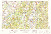
~ Tupelo MS topo map, 1:250000 scale, 1 X 2 Degree, Historical, 1956, updated 1973
Tupelo, Mississippi, USGS topographic map dated 1956.
Includes geographic coordinates (latitude and longitude). This topographic map is suitable for hiking, camping, and exploring, or framing it as a wall map.
Printed on-demand using high resolution imagery, on heavy weight and acid free paper, or alternatively on a variety of synthetic materials.
Topos available on paper, Waterproof, Poly, or Tyvek. Usually shipping rolled, unless combined with other folded maps in one order.
- Product Number: USGS-5599112
- Free digital map download (high-resolution, GeoPDF): Tupelo, Mississippi (file size: 19 MB)
- Map Size: please refer to the dimensions of the GeoPDF map above
- Weight (paper map): ca. 55 grams
- Map Type: POD USGS Topographic Map
- Map Series: HTMC
- Map Verison: Historical
- Cell ID: 69065
- Scan ID: 337280
- Imprint Year: 1973
- Woodland Tint: Yes
- Aerial Photo Year: 1953
- Edit Year: 1970
- Field Check Year: 1956
- Datum: Unstated
- Map Projection: Transverse Mercator
- Map published by: Military, Other
- Map Language: English
- Scanner Resolution: 600 dpi
- Map Cell Name: Tupelo
- Grid size: 1 X 2 Degree
- Date on map: 1956
- Map Scale: 1:250000
- Geographical region: Mississippi, United States
Neighboring Maps:
All neighboring USGS topo maps are available for sale online at a variety of scales.
Spatial coverage:
Topo map Tupelo, Mississippi, covers the geographical area associated the following places:
- Fulton - Northwood Drive - Tishomingo - Bett - Richmond - Fairview - Henson Springs - Moores Mill - Palestine - Mound City - Chateau Le Blanc - Barton - Brittany Woods - West Corinth - Waterloo - Woodland Hills Estates - Central Academy - Hideaway Hills - Eureka Springs - Shiloh - Cairo - University - Prairie Mount (historical) - Dennis - Lar-Eli-Do - Forest Hills - Sarepta - Indian Hills - Detroit - Sharon Hills - Oakland - Denmark - Watson Center - Brownfield - Ellistown - Cooks Landing - Briarwood - Farmington - Bissell - Myrtle - Doskie - Cardsville - Banner - Boggan Grove - Harrisburg Heights - Concord - Glenfield - Oakcliff Villas - Leotis - Crossroad - East Prentiss - Alphaba - Mount Moriah - Hebron - Pleasant Ridge - Shady Acres - Theo - Lewisburg - Tyro - Paden - Bluff - Blue Springs - Woodland - Flinn - Old Myrtle - Jobes - Burntout - Iuka - Bloody Springs - Centerville - Eggville - Galena - Burt - Hopewell - Mynot - Knights Acres - Ingleton (historical) - Rollings Woods - Old Burleson - Old Houlka - Frankstown - North Park - Laws Hill - Camp Ground - Beans Ferry - Pine Grove - Bristow - Enterprise - Boggan Bend - Booneville - Bounds Crossroads - Bexar - Shaw (historical) - Springville - Beech Springs - Courtland - Wilemon - The Dell - Lee Acres - Houlka
- Map Area ID: AREA3534-90-88
- Northwest corner Lat/Long code: USGSNW35-90
- Northeast corner Lat/Long code: USGSNE35-88
- Southwest corner Lat/Long code: USGSSW34-90
- Southeast corner Lat/Long code: USGSSE34-88
- Northern map edge Latitude: 35
- Southern map edge Latitude: 34
- Western map edge Longitude: -90
- Eastern map edge Longitude: -88


