
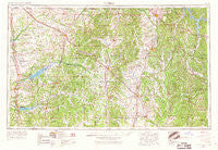
~ Tupelo MS topo map, 1:250000 scale, 1 X 2 Degree, Historical, 1956, updated 1967
Tupelo, Mississippi, USGS topographic map dated 1956.
Includes geographic coordinates (latitude and longitude). This topographic map is suitable for hiking, camping, and exploring, or framing it as a wall map.
Printed on-demand using high resolution imagery, on heavy weight and acid free paper, or alternatively on a variety of synthetic materials.
Topos available on paper, Waterproof, Poly, or Tyvek. Usually shipping rolled, unless combined with other folded maps in one order.
- Product Number: USGS-5599110
- Free digital map download (high-resolution, GeoPDF): Tupelo, Mississippi (file size: 18 MB)
- Map Size: please refer to the dimensions of the GeoPDF map above
- Weight (paper map): ca. 55 grams
- Map Type: POD USGS Topographic Map
- Map Series: HTMC
- Map Verison: Historical
- Cell ID: 69065
- Scan ID: 337279
- Imprint Year: 1967
- Woodland Tint: Yes
- Edit Year: 1966
- Field Check Year: 1966
- Datum: Unstated
- Map Projection: Transverse Mercator
- Map published by United States Army Corps of Engineers
- Map published by United States Army
- Map Language: English
- Scanner Resolution: 600 dpi
- Map Cell Name: Tupelo
- Grid size: 1 X 2 Degree
- Date on map: 1956
- Map Scale: 1:250000
- Geographical region: Mississippi, United States
Neighboring Maps:
All neighboring USGS topo maps are available for sale online at a variety of scales.
Spatial coverage:
Topo map Tupelo, Mississippi, covers the geographical area associated the following places:
- Wallace - Edgemont - Haddock (historical) - Clarysville - Oak Hill - Rolling Woods - Lespedeza - North Park - Lake Piomingo - Kirkville - Wilco Estates - Alpine - Bethlehem - Floyton (historical) - Carter Branch - Guntown - Paden - Camargo (historical) - McCluney (historical) - New Harmony - Aiken - Water Valley - Blythes Chapel - Markette - Rogers Acres - Prairie Mount (historical) - Kossuth - Taylor - Biggersville - Chalybeate - New Hope - Fairhaven - Rockhill - Foxmoor - Thrasher - West Corinth - Concord - Denmark - Gaston - Meadowview - Atway - Parham - Glenville - Lafayette Springs - Clay - Lurline - Mount Vernon - Crossroad - High Point - Wallfield - Neil - Jago - Etta - Shake Rag (historical) - Mingo - Good Springs (historical) - Hebron - Locum - Plantersville - New Albany - Bynum - Pleasant Hill - Pisgah - Halltown - Parkway - Bristow Acres - Pleasant Hill - Old Union - Pratts - Seven Pines - Pine Grove - Northwood Estates - Tyro - Rollings Woods - Wallace Creek - Beans Ferry - Oakridge - Booneville - Crumtown - North Haven - Petertown - Bett - Altus - Detroit - Ecru - Linwood Subdivision - Orion - The Dell - Sardis - Country Oak Estates - Senatobia Lakes - Hickory Flat (historical) - State Line (historical) - Cairo - Okolona - Hobo Station - Praise Acres - Glens - Pine Flat - Cross Roads
- Map Area ID: AREA3534-90-88
- Northwest corner Lat/Long code: USGSNW35-90
- Northeast corner Lat/Long code: USGSNE35-88
- Southwest corner Lat/Long code: USGSSW34-90
- Southeast corner Lat/Long code: USGSSE34-88
- Northern map edge Latitude: 35
- Southern map edge Latitude: 34
- Western map edge Longitude: -90
- Eastern map edge Longitude: -88


