
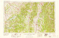
~ Tupelo MS topo map, 1:250000 scale, 1 X 2 Degree, Historical, 1958, updated 1958
Tupelo, Mississippi, USGS topographic map dated 1958.
Includes geographic coordinates (latitude and longitude). This topographic map is suitable for hiking, camping, and exploring, or framing it as a wall map.
Printed on-demand using high resolution imagery, on heavy weight and acid free paper, or alternatively on a variety of synthetic materials.
Topos available on paper, Waterproof, Poly, or Tyvek. Usually shipping rolled, unless combined with other folded maps in one order.
- Product Number: USGS-5599108
- Free digital map download (high-resolution, GeoPDF): Tupelo, Mississippi (file size: 19 MB)
- Map Size: please refer to the dimensions of the GeoPDF map above
- Weight (paper map): ca. 55 grams
- Map Type: POD USGS Topographic Map
- Map Series: HTMC
- Map Verison: Historical
- Cell ID: 69065
- Scan ID: 337278
- Imprint Year: 1958
- Woodland Tint: Yes
- Field Check Year: 1956
- Datum: Unstated
- Map Projection: Transverse Mercator
- Map published by United States Geological Survey
- Map published by United States Army Corps of Engineers
- Map published by United States Army
- Map Language: English
- Scanner Resolution: 600 dpi
- Map Cell Name: Tupelo
- Grid size: 1 X 2 Degree
- Date on map: 1958
- Map Scale: 1:250000
- Geographical region: Mississippi, United States
Neighboring Maps:
All neighboring USGS topo maps are available for sale online at a variety of scales.
Spatial coverage:
Topo map Tupelo, Mississippi, covers the geographical area associated the following places:
- Palestine - Wakefield - Ecru - Michigan City - Oak Grove (historical) - Doskie - Frankstown - Pinehurst - Oakland - New Bethel - Weston - Suburban Acres - Shannon - Tracewood - Glenfield - Mount Olivet - Sunflower - Campbellton (historical) - Verona Heights - Macedonia - Graham - Smithville - Bright - Crows Camp (historical) - Taska - Haven Acres - Wheeler - Hickory Flat - Fulton Bridge - Lakeside - Handy Corner - New Canaan - Shuford - Fairfield - Toccopola - Glens - University - Furrs - Goodford - Lake Center - Rogers Acres - Eastman - Edgemont - Buena Vista - Smalco - Bett - Long Branch - Chesterville - Free Springs - Endville - Wildwood - Mount Moriah - Lakewood Park - Burton - Hopewell - Patterson Subdivision - Barr - Concord - Ellistown - Yocona - Coggin Subdivision - Neil - Falkner - Northwood Drive - Blackwater - Burntout - Water Valley Landing - Collins Crossing - Fairhaven - Old Union - Riggins - New Town - Pinecrest - Keel - East Prentiss - Brennan Subdivision - Lamar - Velma - Okolona - Rockhill - Dumas - Potlockney - Locust Grove - Burt - Markette - Bristow - Terrace Park - Bounds Crossroads - Waterloo - Eureka Springs - Colbert (historical) - Union - Cornish - Snow Lake Shores - Pine Grove - Hernando - Fawn Meadows - Unity - Dennis - Rocky Ford
- Map Area ID: AREA3534-90-88
- Northwest corner Lat/Long code: USGSNW35-90
- Northeast corner Lat/Long code: USGSNE35-88
- Southwest corner Lat/Long code: USGSSW34-90
- Southeast corner Lat/Long code: USGSSE34-88
- Northern map edge Latitude: 35
- Southern map edge Latitude: 34
- Western map edge Longitude: -90
- Eastern map edge Longitude: -88


