
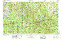
~ Meridian MS topo map, 1:250000 scale, 1 X 2 Degree, Historical, 1953, updated 1974
Meridian, Mississippi, USGS topographic map dated 1953.
Includes geographic coordinates (latitude and longitude). This topographic map is suitable for hiking, camping, and exploring, or framing it as a wall map.
Printed on-demand using high resolution imagery, on heavy weight and acid free paper, or alternatively on a variety of synthetic materials.
Topos available on paper, Waterproof, Poly, or Tyvek. Usually shipping rolled, unless combined with other folded maps in one order.
- Product Number: USGS-5599096
- Free digital map download (high-resolution, GeoPDF): Meridian, Mississippi (file size: 22 MB)
- Map Size: please refer to the dimensions of the GeoPDF map above
- Weight (paper map): ca. 55 grams
- Map Type: POD USGS Topographic Map
- Map Series: HTMC
- Map Verison: Historical
- Cell ID: 72239
- Scan ID: 337272
- Imprint Year: 1974
- Woodland Tint: Yes
- Aerial Photo Year: 1968
- Edit Year: 1970
- Field Check Year: 1953
- Datum: Unstated
- Map Projection: Transverse Mercator
- Map published by: Military, Other
- Map Language: English
- Scanner Resolution: 600 dpi
- Map Cell Name: Meridian
- Grid size: 1 X 2 Degree
- Date on map: 1953
- Map Scale: 1:250000
- Geographical region: Mississippi, United States
Neighboring Maps:
All neighboring USGS topo maps are available for sale online at a variety of scales.
Spatial coverage:
Topo map Meridian, Mississippi, covers the geographical area associated the following places:
- Lavaca - New Fellowship - Redwater - Chapel Hill - Fairhill - Pelahatchie - Battle Bluff - Gholson - Eureka - Gridley - Kewanee - New Mount Hebron - Suqualena - Farmhaven - Williamsville - Cato - Pisgah - Enondale - Schamberville - Pineville - Basic - Goshen Springs - East Hillsboro - Center Hill - Arunde - Shongelo - Bertice - Cuthi Uckehaca (historical) - Bloomfield - Tuscola - Garlandville - Conehatta - Nile - Liberty - Geiger - Prismatic - Beatrice - Horseshoe - Damascus - Ratliff - Bartlett - Riderwood - Camden - Dixon - Miller - Orange - Little Rock (historical) - Sebastopol - Morgan Chapel - Wautubbee - Rock Springs - Oka Kapassa (historical) - Cross Roads - Joe (historical) - Shuqualak - Coldwater - Quitman - Turnerville - Bethel (historical) - Baxter - Forty (historical) - George (historical) - Jewells Hill (historical) - Lingle - Poplar Springs - Hickory - Pine Springs - Union - Noxapater - Old Scooba (historical) - Arlington - Kemper Springs - Sharon - Tallow (historical) - Damascus - Kinterbish - Salem - Sandtown - Lemon - Bluffport - Carters - Roberts - Sun - Fannin - Lynwood (historical) - Electric Mills - Harperville - Gum Springs - Hubbard - Tompkinsville - Hatchette (historical) - Mohegan (historical) - Nanih Waiya - Edinburg - Sykes - Russell - Naheola - Chunky - Shady Dell (historical) - Otho
- Map Area ID: AREA3332-90-88
- Northwest corner Lat/Long code: USGSNW33-90
- Northeast corner Lat/Long code: USGSNE33-88
- Southwest corner Lat/Long code: USGSSW32-90
- Southeast corner Lat/Long code: USGSSE32-88
- Northern map edge Latitude: 33
- Southern map edge Latitude: 32
- Western map edge Longitude: -90
- Eastern map edge Longitude: -88


