
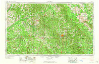
~ Meridian MS topo map, 1:250000 scale, 1 X 2 Degree, Historical, 1965, updated 1965
Meridian, Mississippi, USGS topographic map dated 1965.
Includes geographic coordinates (latitude and longitude). This topographic map is suitable for hiking, camping, and exploring, or framing it as a wall map.
Printed on-demand using high resolution imagery, on heavy weight and acid free paper, or alternatively on a variety of synthetic materials.
Topos available on paper, Waterproof, Poly, or Tyvek. Usually shipping rolled, unless combined with other folded maps in one order.
- Product Number: USGS-5599092
- Free digital map download (high-resolution, GeoPDF): Meridian, Mississippi (file size: 21 MB)
- Map Size: please refer to the dimensions of the GeoPDF map above
- Weight (paper map): ca. 55 grams
- Map Type: POD USGS Topographic Map
- Map Series: HTMC
- Map Verison: Historical
- Cell ID: 72239
- Scan ID: 337270
- Imprint Year: 1965
- Woodland Tint: Yes
- Aerial Photo Year: 1952
- Field Check Year: 1953
- Datum: Unstated
- Map Projection: Transverse Mercator
- Map published by United States Army Corps of Engineers
- Map published by United States Army
- Map Language: English
- Scanner Resolution: 600 dpi
- Map Cell Name: Meridian
- Grid size: 1 X 2 Degree
- Date on map: 1965
- Map Scale: 1:250000
- Geographical region: Mississippi, United States
Neighboring Maps:
All neighboring USGS topo maps are available for sale online at a variety of scales.
Spatial coverage:
Topo map Meridian, Mississippi, covers the geographical area associated the following places:
- Lebanon - Bethel (historical) - Goshen - Plattsburg - Brandon - Lucern - Urbo (historical) - Stratton - Montrose - Marydell - Cuthi Uckehaca (historical) - Good Hope - Verba - Cross Roads - Burns - Mount Vernon - Chunky (historical) - Pilgrim Grove - Remus - Kemper Springs - Ophelia (historical) - Decatur - Prince Chapel - Pilgrim Rest - Revive - Perdue - Morton - Sand Hill - Moscow - Stinson - Loring - Meehan - Coldwater - East Coongetto (historical) - Piggtown - Pickens - Pulaski - Preston - Crossroads - Usrytown - Lorena - Mollie - Calyx - Hookston - Forestdale - Bailey - York - Philadelphia - Deas - Bluffport - Lillian - Tanglewood - Indian Springs - Lawrence - Scratch Hill - Cameron - Independence - White Oak - Pelahatchie - Paulding - McAfee - New West Greene - Lavaca - Pine Springs - Harperville - Koch - Steele - Chomontakali (historical) - Cleveland - Carthage - Crawford Fork - Sandtown - Old Bluffport - Turnetta - Willoughby - Vimville - Mayhoff Springs (historical) - Tamola - Ball Hill - New Fannin - Dowell - Hazel - Wicker - Dowdville - Easthaven - Saint Ann - Singleton Settlement - Noxapater - Rio - Linton - Ras - Stevens - Gulde - Bethel - Vernon - Kewanee - Morgan Chapel - Muskegon - Houston - Galilee
- Map Area ID: AREA3332-90-88
- Northwest corner Lat/Long code: USGSNW33-90
- Northeast corner Lat/Long code: USGSNE33-88
- Southwest corner Lat/Long code: USGSSW32-90
- Southeast corner Lat/Long code: USGSSE32-88
- Northern map edge Latitude: 33
- Southern map edge Latitude: 32
- Western map edge Longitude: -90
- Eastern map edge Longitude: -88


