
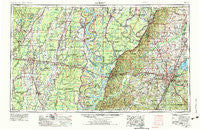
~ Jackson MS topo map, 1:250000 scale, 1 X 2 Degree, Historical, 1955, updated 1975
Jackson, Mississippi, USGS topographic map dated 1955.
Includes geographic coordinates (latitude and longitude). This topographic map is suitable for hiking, camping, and exploring, or framing it as a wall map.
Printed on-demand using high resolution imagery, on heavy weight and acid free paper, or alternatively on a variety of synthetic materials.
Topos available on paper, Waterproof, Poly, or Tyvek. Usually shipping rolled, unless combined with other folded maps in one order.
- Product Number: USGS-5599088
- Free digital map download (high-resolution, GeoPDF): Jackson, Mississippi (file size: 21 MB)
- Map Size: please refer to the dimensions of the GeoPDF map above
- Weight (paper map): ca. 55 grams
- Map Type: POD USGS Topographic Map
- Map Series: HTMC
- Map Verison: Historical
- Cell ID: 68839
- Scan ID: 337268
- Imprint Year: 1975
- Woodland Tint: Yes
- Visual Version Number: 1
- Aerial Photo Year: 1973
- Edit Year: 1973
- Datum: Unstated
- Map Projection: Transverse Mercator
- Map published by United States Geological Survey
- Map published by: Military, Other
- Map Language: English
- Scanner Resolution: 600 dpi
- Map Cell Name: Jackson
- Grid size: 1 X 2 Degree
- Date on map: 1955
- Map Scale: 1:250000
- Geographical region: Mississippi, United States
Neighboring Maps:
All neighboring USGS topo maps are available for sale online at a variety of scales.
Spatial coverage:
Topo map Jackson, Mississippi, covers the geographical area associated the following places:
- Moncure - Yokena - The Briars - Westwood - Twin Bridges - Plumville (historical) - Chase - Comeby (historical) - Ashland Estates - Cary - Lakeside - Sheltons - New Quarters - Somerset - Champion Hill - Nogan - New Landgrove Landing - Simrall - Ratliff Landing - Notnac - Summerwood - Hollands (historical) - Howell (historical) - Paradise Point - Newhlock - Northwoods - Bethesda - Point Pleasant - Big Black - Chapel Landing - Delhi - Riverside Junction - Oak Creek - Carter - Oaklawn - Tensas Bluff - New Fitler - Naff - Terry - Spyker - Log Cabin - Thompson - Peelers - Valley Mills - Redwing - Patton Place - Humphreys - Brookleigh - Clinton - Whitfield - Chelly Landing - Marcarco - Duck Port (historical) - Waller Landing - Ferry Newlight Landing - Afton - Jack - Blakely - Hollybrook - Pearson - Indian Landing - Bear Creek - Grand Gulf - Turtle Creek - Mill Town - Wilson Point (historical) - Jackson - Squirrel Hill - Pilcher Point - Scotland Fork - Kings - Brookwood Pines - Newhope - Village Square - Egremont - Harworth - Craig - Deerfield - Milhaven Estates - Dry Grove - Edwards - Linwood - Bonita - Collinston - Germania - Pearl - Rolling Fork - Tendal - Greenbrook - Bordenax - Saranac - Choctaw Landing - Dixon Acres - Vicksburg - Presidential Hills - Myles - Fleetwood Park - Gaylyn Terrace - Waverly - Stampley
- Map Area ID: AREA3332-92-90
- Northwest corner Lat/Long code: USGSNW33-92
- Northeast corner Lat/Long code: USGSNE33-90
- Southwest corner Lat/Long code: USGSSW32-92
- Southeast corner Lat/Long code: USGSSE32-90
- Northern map edge Latitude: 33
- Southern map edge Latitude: 32
- Western map edge Longitude: -92
- Eastern map edge Longitude: -90


