
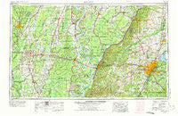
~ Jackson MS topo map, 1:250000 scale, 1 X 2 Degree, Historical, 1955, updated 1975
Jackson, Mississippi, USGS topographic map dated 1955.
Includes geographic coordinates (latitude and longitude). This topographic map is suitable for hiking, camping, and exploring, or framing it as a wall map.
Printed on-demand using high resolution imagery, on heavy weight and acid free paper, or alternatively on a variety of synthetic materials.
Topos available on paper, Waterproof, Poly, or Tyvek. Usually shipping rolled, unless combined with other folded maps in one order.
- Product Number: USGS-5599086
- Free digital map download (high-resolution, GeoPDF): Jackson, Mississippi (file size: 20 MB)
- Map Size: please refer to the dimensions of the GeoPDF map above
- Weight (paper map): ca. 55 grams
- Map Type: POD USGS Topographic Map
- Map Series: HTMC
- Map Verison: Historical
- Cell ID: 68839
- Scan ID: 337267
- Imprint Year: 1975
- Woodland Tint: Yes
- Aerial Photo Year: 1973
- Edit Year: 1973
- Field Check Year: 1955
- Datum: Unstated
- Map Projection: Transverse Mercator
- Map published by United States Geological Survey
- Map published by: Military, Other
- Map Language: English
- Scanner Resolution: 600 dpi
- Map Cell Name: Jackson
- Grid size: 1 X 2 Degree
- Date on map: 1955
- Map Scale: 1:250000
- Geographical region: Mississippi, United States
Neighboring Maps:
All neighboring USGS topo maps are available for sale online at a variety of scales.
Spatial coverage:
Topo map Jackson, Mississippi, covers the geographical area associated the following places:
- Onward - Forest Point - Adams - Elton - Mason - Cleary - Brunswick - Tisdell Landing - Buie - Rosemary - Naff - Morning Star - Alsatia - Cynthia - Big Creek - New Hope Grove - Southwood Estates - Twin Lake - Jigger - Anderson - Millrun - Mill Creek Place - Millhaven - Moncure - Lake Ridgelea Subdivision - Waller Landing - Colby - Humphreys - Issaquena - Woodlawn - Mill Creek - Newman - Jonestown - Treasure Cove - Oil City - The Briars - Midway - Champion Hill - Patton Place - Hickory Glen - Woodhaven - New Landgrove Landing - Sandalwood - Scott Landing - Ebenezer - Millikin - Northwoods - County Acres - Shady Springs Mobile Home Community - Start - Dixon Road Mobile Home Park - Alto - Waddell - North Colony - Byram - Ingomar (historical) - Wilson Point (historical) - Canton - Kelso - Charlton - Summertree - Timberlane - Quimby - Harbourview - Bedford - Sherwood Forest - Twin Oaks - Chapel Landing - Creekwood Place - Little Sunflower - Big Eddy Landing - The Commons - Spyker - Porters Chapel - Hidden Oaks - Country Place - Baskinton - Pocahontas - Eden - Nod - Swampers - Bear Skin - Anchorage - Stevenson - Dover (historical) - Arcadia (historical) - Hancock - Lorelein - Gateway North - Deerfield - Squirrel Hill - McRaven - Rawhide - Ashland Estates - Coleman - Presidential Hills - Cedar Hill (historical) - Tidewater - Kearney - Laark
- Map Area ID: AREA3332-92-90
- Northwest corner Lat/Long code: USGSNW33-92
- Northeast corner Lat/Long code: USGSNE33-90
- Southwest corner Lat/Long code: USGSSW32-92
- Southeast corner Lat/Long code: USGSSE32-90
- Northern map edge Latitude: 33
- Southern map edge Latitude: 32
- Western map edge Longitude: -92
- Eastern map edge Longitude: -90


