
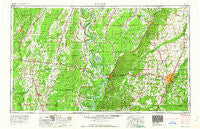
~ Jackson MS topo map, 1:250000 scale, 1 X 2 Degree, Historical, 1962, updated 1962
Jackson, Mississippi, USGS topographic map dated 1962.
Includes geographic coordinates (latitude and longitude). This topographic map is suitable for hiking, camping, and exploring, or framing it as a wall map.
Printed on-demand using high resolution imagery, on heavy weight and acid free paper, or alternatively on a variety of synthetic materials.
Topos available on paper, Waterproof, Poly, or Tyvek. Usually shipping rolled, unless combined with other folded maps in one order.
- Product Number: USGS-5599082
- Free digital map download (high-resolution, GeoPDF): Jackson, Mississippi (file size: 19 MB)
- Map Size: please refer to the dimensions of the GeoPDF map above
- Weight (paper map): ca. 55 grams
- Map Type: POD USGS Topographic Map
- Map Series: HTMC
- Map Verison: Historical
- Cell ID: 68839
- Scan ID: 337265
- Imprint Year: 1962
- Woodland Tint: Yes
- Edit Year: 1962
- Field Check Year: 1955
- Datum: Unstated
- Map Projection: Transverse Mercator
- Map published by United States Army Corps of Engineers
- Map published by United States Army
- Map Language: English
- Scanner Resolution: 600 dpi
- Map Cell Name: Jackson
- Grid size: 1 X 2 Degree
- Date on map: 1962
- Map Scale: 1:250000
- Geographical region: Mississippi, United States
Neighboring Maps:
All neighboring USGS topo maps are available for sale online at a variety of scales.
Spatial coverage:
Topo map Jackson, Mississippi, covers the geographical area associated the following places:
- Byrd Heights - Hickory Glen - Stampley - Dehlco - Evans - Whites - New Quarters - Oak Landing - Jigger - Pecan Landing - Crump - Kings - Tidewater - Hurricane - Nogan - Bernard - Villanova - Flowood - Carmichael - Fortune Fork - Warsaw Landing - Anchorage - Rolling Fork - Northwest Hills - Randall Place - Stones Landing - Raintree Place - Davis - Heritage Estates - Phoenix - Egypt Hill - Highland Meadows - Star - Goodwill - Mill Creek - Robinson Springs - Lorenzen - Forest - Cedar Hill - Roses Bluff - Lebanon - Cayuga - Wardville - Point Pleasant - Tavern Hill - Mason - Myles - Laark - Pecan Creek - Rawhide - Richmond - Tougaloo - Mannsdale - Deerfield - Myrleville - Sacksonia - Patton Place - Canton - Fairchilds Crossroads - Madison - Skyway Hills - Big Eddy Landing - Patosi - Northpointe - Cary - Redwood - Clear Branch - Barnes Prairie - Wildcat - George - Dixie Landing - Germania - Hope Springs - Bear Skin - Jeff Davis - Monticello - Florence - Bakers - Reedtown - Midway - Lakeside - Sherwood Forest - Renshaw - Valley - Oak Ridge - Cedars - Pat - Shadow Lake Estates - Pearl - Tinsley - Turtle Creek - Quail Creek Estates - Collinston - Lorelein - Lake Ridgelea Subdivision - Patmos - Mayersville - Dover - Hankinson - Elleslie
- Map Area ID: AREA3332-92-90
- Northwest corner Lat/Long code: USGSNW33-92
- Northeast corner Lat/Long code: USGSNE33-90
- Southwest corner Lat/Long code: USGSSW32-92
- Southeast corner Lat/Long code: USGSSE32-90
- Northern map edge Latitude: 33
- Southern map edge Latitude: 32
- Western map edge Longitude: -92
- Eastern map edge Longitude: -90


