
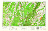
~ Jackson MS topo map, 1:250000 scale, 1 X 2 Degree, Historical, 1961, updated 1961
Jackson, Mississippi, USGS topographic map dated 1961.
Includes geographic coordinates (latitude and longitude). This topographic map is suitable for hiking, camping, and exploring, or framing it as a wall map.
Printed on-demand using high resolution imagery, on heavy weight and acid free paper, or alternatively on a variety of synthetic materials.
Topos available on paper, Waterproof, Poly, or Tyvek. Usually shipping rolled, unless combined with other folded maps in one order.
- Product Number: USGS-5599080
- Free digital map download (high-resolution, GeoPDF): Jackson, Mississippi (file size: 20 MB)
- Map Size: please refer to the dimensions of the GeoPDF map above
- Weight (paper map): ca. 55 grams
- Map Type: POD USGS Topographic Map
- Map Series: HTMC
- Map Verison: Historical
- Cell ID: 68839
- Scan ID: 337264
- Imprint Year: 1961
- Woodland Tint: Yes
- Field Check Year: 1955
- Datum: Unstated
- Map Projection: Transverse Mercator
- Map published by United States Army Corps of Engineers
- Map published by United States Army
- Map Language: English
- Scanner Resolution: 600 dpi
- Map Cell Name: Jackson
- Grid size: 1 X 2 Degree
- Date on map: 1961
- Map Scale: 1:250000
- Geographical region: Mississippi, United States
Neighboring Maps:
All neighboring USGS topo maps are available for sale online at a variety of scales.
Spatial coverage:
Topo map Jackson, Mississippi, covers the geographical area associated the following places:
- Terry - Cedars - Bakers - Katzenmeyer - Tinnin - Morning Star - Millhaven - Rolling Fork - Bonita - Mer Rouge - Deasonville - Lakeside - Issaquena - Hankinson - Pioneer - Madison - Crossgates - Bethesda (historical) - Bushes - Mill Creek Corners - Flowers - Brookwood - Plain - Bayland - Kentwood - Crew Lake - Anguilla - Loch Lomond - Baskinton - Jones - Seven Springs - Bottom Acres - Gum Ridge - New Byram - New Landgrove Landing - Sacksonia - Valley - Valley Mills - Darnell - Charlton - Terrapin Hill - Berryville - Eagle Bend - Lotts Mobile Home Park - Hope Springs - Salem - Sloan - Twin Bridges - Woodmoor - Trailwood - Lake Forest - Stones Landing - Claibornesville (historical) - Baskin - Willows - Swampers - Richmond - Audubon Park - Hunters Woods - Fugate - Morgans Store - Jackson - Hurricane - Mangham - Ingleside - New Hope Grove - Kimberly - Enola - Warsaw Landing - Peelers - Canton - Queens Hill - Point Pleasant - Hopedale - Adams - Ashland - Floyd - Green - Learned - Beaver Creek - Nevada - The Islands - Newhlock - Thompsonville - Tinsley - Country Club Woods - Flora - King - Como - Tallulah - Lorenzen - Cayuga - Grove Park - Hollands (historical) - Edgewood Acres - Highland - Monterey - Four Forks - Whitfield - Carriage Hills
- Map Area ID: AREA3332-92-90
- Northwest corner Lat/Long code: USGSNW33-92
- Northeast corner Lat/Long code: USGSNE33-90
- Southwest corner Lat/Long code: USGSSW32-92
- Southeast corner Lat/Long code: USGSSE32-90
- Northern map edge Latitude: 33
- Southern map edge Latitude: 32
- Western map edge Longitude: -92
- Eastern map edge Longitude: -90


