
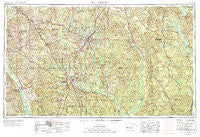
~ Hattiesburg MS topo map, 1:250000 scale, 1 X 2 Degree, Historical, 1953, updated 1976
Hattiesburg, Mississippi, USGS topographic map dated 1953.
Includes geographic coordinates (latitude and longitude). This topographic map is suitable for hiking, camping, and exploring, or framing it as a wall map.
Printed on-demand using high resolution imagery, on heavy weight and acid free paper, or alternatively on a variety of synthetic materials.
Topos available on paper, Waterproof, Poly, or Tyvek. Usually shipping rolled, unless combined with other folded maps in one order.
- Product Number: USGS-5599072
- Free digital map download (high-resolution, GeoPDF): Hattiesburg, Mississippi (file size: 25 MB)
- Map Size: please refer to the dimensions of the GeoPDF map above
- Weight (paper map): ca. 55 grams
- Map Type: POD USGS Topographic Map
- Map Series: HTMC
- Map Verison: Historical
- Cell ID: 68818
- Scan ID: 337262
- Imprint Year: 1976
- Woodland Tint: Yes
- Visual Version Number: 1
- Aerial Photo Year: 1952
- Edit Year: 1970
- Field Check Year: 1953
- Datum: Unstated
- Map Projection: Transverse Mercator
- Map published by: Military, Other
- Map Language: English
- Scanner Resolution: 600 dpi
- Map Cell Name: Hattiesburg
- Grid size: 1 X 2 Degree
- Date on map: 1953
- Map Scale: 1:250000
- Geographical region: Mississippi, United States
Neighboring Maps:
All neighboring USGS topo maps are available for sale online at a variety of scales.
Spatial coverage:
Topo map Hattiesburg, Mississippi, covers the geographical area associated the following places:
- Shivers - Old Samuel - Salitpa - Eucutta - Threadville - Creek (historical) - Richburg Heights - Seneca - Chicora - Citronelle - Bucks - Womack Hill - Saxon - Walters - Errata - Center Point - Lovelace - Magee - McNair - Benjoe - Hoy - Cooley Springs - Sunflower - Oak Vale - Mount Pleasant - Powers - Albeison - Bynum - New Union - Fortenberry - Souwilpa - Sharon - Sunrise - Amy - Cunningham - Chastang - Hawkes - Silver Creek - Tawanta - Henderson - Saratoga - Vernon - Rainey - Ridgecrest Mobile Home Park - Berkshire Hills - Forrest Garden Mobile Home Park - Wisner - Westover - Arnold Line - Toxey - Hamage - Lamar Pines Mobile Home Community - Bedford Woods - Sumbax - Okahola - Expose - Dexter - Lucas - Silver Cross - Fakit Chipunta (historical) - Leaf - Tuckers Crossing - Old Bassfield (historical) - Pinola - Shady Grove - Weathersby - Barnett - Isney - Lou - Clyde - Riverside - New Hebron - Barrontown - Heatherwood Estates - Beaumont - Martinville - Millry - Epworth - Cohay - Providence - Carson - Varnado - McCallum - Tall Pines - Mineral Springs - Bladon Springs - Leakesville - Bashi - Westwood - Fruitdale - Williamsburg - Terrell - Enon - Sharon Acres - Wardwell - Hurricane Creek - Sunset - Bassetts Creek - Union - Lightsey
- Map Area ID: AREA3231-90-88
- Northwest corner Lat/Long code: USGSNW32-90
- Northeast corner Lat/Long code: USGSNE32-88
- Southwest corner Lat/Long code: USGSSW31-90
- Southeast corner Lat/Long code: USGSSE31-88
- Northern map edge Latitude: 32
- Southern map edge Latitude: 31
- Western map edge Longitude: -90
- Eastern map edge Longitude: -88


