
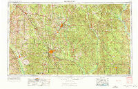
~ Hattiesburg MS topo map, 1:250000 scale, 1 X 2 Degree, Historical, 1953, updated 1972
Hattiesburg, Mississippi, USGS topographic map dated 1953.
Includes geographic coordinates (latitude and longitude). This topographic map is suitable for hiking, camping, and exploring, or framing it as a wall map.
Printed on-demand using high resolution imagery, on heavy weight and acid free paper, or alternatively on a variety of synthetic materials.
Topos available on paper, Waterproof, Poly, or Tyvek. Usually shipping rolled, unless combined with other folded maps in one order.
- Product Number: USGS-5599070
- Free digital map download (high-resolution, GeoPDF): Hattiesburg, Mississippi (file size: 23 MB)
- Map Size: please refer to the dimensions of the GeoPDF map above
- Weight (paper map): ca. 55 grams
- Map Type: POD USGS Topographic Map
- Map Series: HTMC
- Map Verison: Historical
- Cell ID: 68818
- Scan ID: 337261
- Imprint Year: 1972
- Woodland Tint: Yes
- Aerial Photo Year: 1952
- Edit Year: 1970
- Field Check Year: 1953
- Datum: Unstated
- Map Projection: Transverse Mercator
- Map published by: Military, Other
- Map Language: English
- Scanner Resolution: 600 dpi
- Map Cell Name: Hattiesburg
- Grid size: 1 X 2 Degree
- Date on map: 1953
- Map Scale: 1:250000
- Geographical region: Mississippi, United States
Neighboring Maps:
All neighboring USGS topo maps are available for sale online at a variety of scales.
Spatial coverage:
Topo map Hattiesburg, Mississippi, covers the geographical area associated the following places:
- Wardwell - McLaurin - Escatawpa - Janice - Leakesville - Shadow Wood - Rutan - Tattlersville - Weems (historical) - Hopewell - Sumbax - Cullomburg - Saratoga - Mount Carmel - Kittrell - Spring Cottage - Smithtown - Service - Old Avera - Cheraw - Cold Springs - Leeville - Richburg Heights - Four Points - Mehaffey - Fortenberry - Avera - Simpson - Walters - Brewer - West Bend - Progress - Threadville - Antioch - Eret - Carterville - Goss - Melvin - Gandsi - Hodgewood - Shivers - Emmanuel - Union - Taylorsville - Higgins - Winchester - Claiborne (historical) - Upton - Scoutshire Woods - Weathersby - Epley - Ridgecrest Mobile Home Park - Kola - Tawanta - Bigbee - Pot Likker Mobile Home Park - Yellow Pine - Glade - Woodwards - Arbo - Fitee - Dragon - Corinth - Failetown - Columbia - Eminence - Kittrell - Leaf - Lanham - Calvert - Crandall - Enon - Pine Ridge - Bezer - Kensington Woods - Gretna - Epworth - McSwain - Stringer - Davisville (historical) - Langsdale - Cantwell Mill - De Soto - Eastabuchie - Pendorff - Bashi - Richton - New Hebron - Queensburg - Magee - Gin (historical) - Forrest Hills - Keno (historical) - Rocky Branch - Pecan Grove Mobile Home Park - Ellisville - New Wakefield - Hoy - Talowah - Berkshire Hills
- Map Area ID: AREA3231-90-88
- Northwest corner Lat/Long code: USGSNW32-90
- Northeast corner Lat/Long code: USGSNE32-88
- Southwest corner Lat/Long code: USGSSW31-90
- Southeast corner Lat/Long code: USGSSE31-88
- Northern map edge Latitude: 32
- Southern map edge Latitude: 31
- Western map edge Longitude: -90
- Eastern map edge Longitude: -88


