
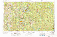
~ Hattiesburg MS topo map, 1:250000 scale, 1 X 2 Degree, Historical, 1953, updated 1976
Hattiesburg, Mississippi, USGS topographic map dated 1953.
Includes geographic coordinates (latitude and longitude). This topographic map is suitable for hiking, camping, and exploring, or framing it as a wall map.
Printed on-demand using high resolution imagery, on heavy weight and acid free paper, or alternatively on a variety of synthetic materials.
Topos available on paper, Waterproof, Poly, or Tyvek. Usually shipping rolled, unless combined with other folded maps in one order.
- Product Number: USGS-5599068
- Free digital map download (high-resolution, GeoPDF): Hattiesburg, Mississippi (file size: 22 MB)
- Map Size: please refer to the dimensions of the GeoPDF map above
- Weight (paper map): ca. 55 grams
- Map Type: POD USGS Topographic Map
- Map Series: HTMC
- Map Verison: Historical
- Cell ID: 68818
- Scan ID: 337260
- Imprint Year: 1976
- Woodland Tint: Yes
- Aerial Photo Year: 1952
- Edit Year: 1970
- Field Check Year: 1953
- Datum: Unstated
- Map Projection: Transverse Mercator
- Map published by: Military, Other
- Map Language: English
- Scanner Resolution: 600 dpi
- Map Cell Name: Hattiesburg
- Grid size: 1 X 2 Degree
- Date on map: 1953
- Map Scale: 1:250000
- Geographical region: Mississippi, United States
Neighboring Maps:
All neighboring USGS topo maps are available for sale online at a variety of scales.
Spatial coverage:
Topo map Hattiesburg, Mississippi, covers the geographical area associated the following places:
- Pineola - Pendorff - Russell - Blodgett - Wimbly - Carson City - Deer Park - Dunbar - Saxon - Reid Settlement - Lambert - Flatwood - Byrd - Clara - Brown Town - Purvis - Lumberton - Lux - Chappell Hill - Ferguson - Tuckers Crossing - Carmichael - Leaf River - Cullomburg - Brightwater - Antioch - Goodluck - Bunker Hill - Seminary - Kelly - Varnado - Magee - Saint Stephens - Foxworth - Bush - Ridgecrest Mobile Home Park - Barrytown - Fanning - Pistol Ridge - Liberty - Eiler - Forrest Garden Mobile Home Park - Hiwannee - Powers - Laton Hill - Baxterville - Errata - Barlow - Matthews - Merry Hell - McRaney - Mount Horeb - Rock Hill - Loper - Kilsby Mobile Home Park - Bonhomie - Matherville - Talowah - Needham - Benjoe - Rounsaville - Arbo - Millry - Blakley Creek - Koenton - Cold Springs - Boice - Mehaffey - Vernon - Spring Hill - Smyer - Leeville - Eastview - West King - Tokio - Goss - Ararat - Station Creek - Souwilpa - Natcole - Happy Hill - Sharon - Pine Grove - Citronelle - Mish - Glendale - Buckatunna - Country Club Estates - Merit - Woodhaven - Regency Estates - Fairford - Keno (historical) - Brewer - Jordan - Lamar Pines Mobile Home Community - Bradley - Gambrell - McLain - Harmon
- Map Area ID: AREA3231-90-88
- Northwest corner Lat/Long code: USGSNW32-90
- Northeast corner Lat/Long code: USGSNE32-88
- Southwest corner Lat/Long code: USGSSW31-90
- Southeast corner Lat/Long code: USGSSE31-88
- Northern map edge Latitude: 32
- Southern map edge Latitude: 31
- Western map edge Longitude: -90
- Eastern map edge Longitude: -88


