
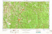
~ Hattiesburg MS topo map, 1:250000 scale, 1 X 2 Degree, Historical, 1953, updated 1965
Hattiesburg, Mississippi, USGS topographic map dated 1953.
Includes geographic coordinates (latitude and longitude). This topographic map is suitable for hiking, camping, and exploring, or framing it as a wall map.
Printed on-demand using high resolution imagery, on heavy weight and acid free paper, or alternatively on a variety of synthetic materials.
Topos available on paper, Waterproof, Poly, or Tyvek. Usually shipping rolled, unless combined with other folded maps in one order.
- Product Number: USGS-5599066
- Free digital map download (high-resolution, GeoPDF): Hattiesburg, Mississippi (file size: 22 MB)
- Map Size: please refer to the dimensions of the GeoPDF map above
- Weight (paper map): ca. 55 grams
- Map Type: POD USGS Topographic Map
- Map Series: HTMC
- Map Verison: Historical
- Cell ID: 68818
- Scan ID: 337259
- Imprint Year: 1965
- Woodland Tint: Yes
- Aerial Photo Year: 1952
- Edit Year: 1964
- Field Check Year: 1953
- Datum: Unstated
- Map Projection: Transverse Mercator
- Map published by United States Geological Survey
- Map published by United States Army Corps of Engineers
- Map published by United States Army
- Map Language: English
- Scanner Resolution: 600 dpi
- Map Cell Name: Hattiesburg
- Grid size: 1 X 2 Degree
- Date on map: 1953
- Map Scale: 1:250000
- Geographical region: Mississippi, United States
Neighboring Maps:
All neighboring USGS topo maps are available for sale online at a variety of scales.
Spatial coverage:
Topo map Hattiesburg, Mississippi, covers the geographical area associated the following places:
- Indian Springs - Rounsaville - Lake Serene North - Woodhaven - Matherville - Richton - Eret - Threadville - Ovett - Deer Park - Hebron - Varnado - Walters - Barnett - Epps - Morris - Beaumont - Bassfield - Dunbar - Eatonville - Bogueloosa - Lanham - Mount Horeb - Malcolm - Weathersby - Escatawpa - Mish - Ralston - Springhill - Bucks - Sunrise - Service - Dedwylder - Innswood - Needham - Bunker Hill - Pleasant Hill - Calhoun - Smithtown - Citronelle - Dragon - Buckatunna - Goodluck - Improve - Hebron - Haw Pond (historical) - Old Avera - Zion Hill - Jordan - Pinebur - Belleville - Old Samuel - Carmichael - Runnelstown - Hale - Topton - New Wakefield - Sels Prairie - Jackson Spur - Carson City - Kola - Errata - Hanford - Cheraw - Zion Hill - Bedford Woods - Mill Creek - Good Hope - Lumberton - Evansboro - Cohay - Cold Springs - Failetown - Smyer - Silver Cross - Oak Grove - Harmony - Okatuppa - Barlow - Davisville (historical) - Lone Star - Saint Paul - Bunker Hill - Whistler - Martinville - Jaynesville - Etchehoma (historical) - Souwilpa - Robinsons Junction - New Union - Barrontown - Laton Hill - Flynt - Saint Stephens - Okahola - Pinola - Claiborne (historical) - Maddox - Nancy - Rescueville
- Map Area ID: AREA3231-90-88
- Northwest corner Lat/Long code: USGSNW32-90
- Northeast corner Lat/Long code: USGSNE32-88
- Southwest corner Lat/Long code: USGSSW31-90
- Southeast corner Lat/Long code: USGSSE31-88
- Northern map edge Latitude: 32
- Southern map edge Latitude: 31
- Western map edge Longitude: -90
- Eastern map edge Longitude: -88


