
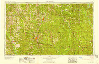
~ Hattiesburg MS topo map, 1:250000 scale, 1 X 2 Degree, Historical, 1958, updated 1958
Hattiesburg, Mississippi, USGS topographic map dated 1958.
Includes geographic coordinates (latitude and longitude). This topographic map is suitable for hiking, camping, and exploring, or framing it as a wall map.
Printed on-demand using high resolution imagery, on heavy weight and acid free paper, or alternatively on a variety of synthetic materials.
Topos available on paper, Waterproof, Poly, or Tyvek. Usually shipping rolled, unless combined with other folded maps in one order.
- Product Number: USGS-5599064
- Free digital map download (high-resolution, GeoPDF): Hattiesburg, Mississippi (file size: 22 MB)
- Map Size: please refer to the dimensions of the GeoPDF map above
- Weight (paper map): ca. 55 grams
- Map Type: POD USGS Topographic Map
- Map Series: HTMC
- Map Verison: Historical
- Cell ID: 68818
- Scan ID: 337258
- Imprint Year: 1958
- Woodland Tint: Yes
- Visual Version Number: 1
- Aerial Photo Year: 1952
- Field Check Year: 1953
- Datum: Unstated
- Map Projection: Transverse Mercator
- Map published by United States Army Corps of Engineers
- Map published by United States Army
- Map Language: English
- Scanner Resolution: 600 dpi
- Map Cell Name: Hattiesburg
- Grid size: 1 X 2 Degree
- Date on map: 1958
- Map Scale: 1:250000
- Geographical region: Mississippi, United States
Neighboring Maps:
All neighboring USGS topo maps are available for sale online at a variety of scales.
Spatial coverage:
Topo map Hattiesburg, Mississippi, covers the geographical area associated the following places:
- Serena Circle Mobile Home Park - Little Creek - Fruitdale - Lightsey - Failetown - Wallis - Cyclone - West King - Eastside - Taylorsville - Okahola - Gay's Mobile Home Park - Hillman - Acme - Clem - Bethel - Burbank - Lone Star - Eastabuchie - Citronelle - Gin (historical) - Lamar Pines Mobile Home Community - Laurel - Service - Cohay - Boice - New Hope - Happy Hill - Eastview - Clara - Gwinville - Malcolm - Ridgecrest Mobile Home Park - Carterville - Mars Hill - Rutan - Hurricane Creek - Jenkins - Zion Hill - Bucks - Oak Forrest - Enon - Piave - Moss - Toinette - Four Point - Rocky Branch - Seminary - Lakewood - Rawls Springs - Hathorn - Salitpa - Thornton Springs - McLain - Saratoga - Cooley Springs - Benjoe - Hanford - Lucas - Ferguson - Rock Springs - Zion Hill - Cleo - Tokio - Brightwater - Vernon - Santee - Bay Springs - Powers - Progress - Markwald - Smyer - Bunker Hill - Kirkwood Park - Waldrup - Flynt - Gitano - Collins - Hawthorn - Topton - Expose - Barlow - Redhill - Vernal - Mount Horeb - Bethel - Crandall - Harvey - Magee - Johnson - Eatonville - Lovelace - Walters - Fanning - Saint Paul - Broadway Trailer Park - Stafford Springs - Woods Bluff - Bedford Woods West - Amy
- Map Area ID: AREA3231-90-88
- Northwest corner Lat/Long code: USGSNW32-90
- Northeast corner Lat/Long code: USGSNE32-88
- Southwest corner Lat/Long code: USGSSW31-90
- Southeast corner Lat/Long code: USGSSE31-88
- Northern map edge Latitude: 32
- Southern map edge Latitude: 31
- Western map edge Longitude: -90
- Eastern map edge Longitude: -88


