
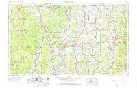
~ Greenwood MS topo map, 1:250000 scale, 1 X 2 Degree, Historical, 1953, updated 1973
Greenwood, Mississippi, USGS topographic map dated 1953.
Includes geographic coordinates (latitude and longitude). This topographic map is suitable for hiking, camping, and exploring, or framing it as a wall map.
Printed on-demand using high resolution imagery, on heavy weight and acid free paper, or alternatively on a variety of synthetic materials.
Topos available on paper, Waterproof, Poly, or Tyvek. Usually shipping rolled, unless combined with other folded maps in one order.
- Product Number: USGS-5599056
- Free digital map download (high-resolution, GeoPDF): Greenwood, Mississippi (file size: 16 MB)
- Map Size: please refer to the dimensions of the GeoPDF map above
- Weight (paper map): ca. 55 grams
- Map Type: POD USGS Topographic Map
- Map Series: HTMC
- Map Verison: Historical
- Cell ID: 68809
- Scan ID: 337254
- Imprint Year: 1973
- Woodland Tint: Yes
- Edit Year: 1965
- Field Check Year: 1953
- Datum: Unstated
- Map Projection: Transverse Mercator
- Map published by United States Army Corps of Engineers
- Map published by United States Army
- Map Language: English
- Scanner Resolution: 600 dpi
- Map Cell Name: Greenwood
- Grid size: 1 X 2 Degree
- Date on map: 1953
- Map Scale: 1:250000
- Geographical region: Mississippi, United States
Neighboring Maps:
All neighboring USGS topo maps are available for sale online at a variety of scales.
Spatial coverage:
Topo map Greenwood, Mississippi, covers the geographical area associated the following places:
- Jaketown - Berea - Blissdale - Parsons - Wade (historical) - Willet - Refuge - Fitzhugh - Hollyknowe - Tamburo (historical) - Minot - Boyle - Lakeport - Mileston - Jeter (historical) - Valley Hill - Flynn - Grass Lake - Floyd - Minter City - Sunflower - Scrouge Out (historical) - Rolfe Junction - Whitney - Peteet - Wilmot - Hollandale - Montongo - Quiver (historical) - Niles - Lloyd - Eudora - James - Dunleith - Silver Lake (historical) - Fresno - Bee Lake - Mount Pleasant - Catfish Point Landing - Eulogy - Relfs Bluff - Terrene Landing - Burdette - Forkland - Yukon - Valley Junction - Wilmot - Choctaw Village (historical) - Enon - Eutaw Landing - Empire - Alder Grove (historical) - Youngstown - Dewey - Brighton - Vickland - Old Milo - Rawls - Morgan City - Collins - Cremer - Deep Elm - Quito - Money - Faisonia - Waxhaw - Pollock (historical) - Avery - Leavits (historical) - Yancopin - Purnell - Cameta - Holly Grove - College Heights - Sunnyside - Reeves (historical) - Red Fork - Greenville - Allis - Paradise (historical) - Shraderville - Masonville - Woodside - Perthshire - Oakhurst Addition - Troy (historical) - Elizabeth - Donbey - Calhoun - Zellner (historical) - Bellewood - Shives - Nitta Yuma - Dwiggins - Ashwood (historical) - Goose Hollow - Swan Lake - Baxter - Belle Prairie - Bethel
- Map Area ID: AREA3433-92-90
- Northwest corner Lat/Long code: USGSNW34-92
- Northeast corner Lat/Long code: USGSNE34-90
- Southwest corner Lat/Long code: USGSSW33-92
- Southeast corner Lat/Long code: USGSSE33-90
- Northern map edge Latitude: 34
- Southern map edge Latitude: 33
- Western map edge Longitude: -92
- Eastern map edge Longitude: -90


