
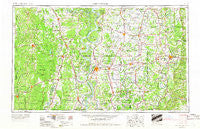
~ Greenwood MS topo map, 1:250000 scale, 1 X 2 Degree, Historical, 1953, updated 1966
Greenwood, Mississippi, USGS topographic map dated 1953.
Includes geographic coordinates (latitude and longitude). This topographic map is suitable for hiking, camping, and exploring, or framing it as a wall map.
Printed on-demand using high resolution imagery, on heavy weight and acid free paper, or alternatively on a variety of synthetic materials.
Topos available on paper, Waterproof, Poly, or Tyvek. Usually shipping rolled, unless combined with other folded maps in one order.
- Product Number: USGS-5599054
- Free digital map download (high-resolution, GeoPDF): Greenwood, Mississippi (file size: 18 MB)
- Map Size: please refer to the dimensions of the GeoPDF map above
- Weight (paper map): ca. 55 grams
- Map Type: POD USGS Topographic Map
- Map Series: HTMC
- Map Verison: Historical
- Cell ID: 68809
- Scan ID: 337253
- Imprint Year: 1966
- Woodland Tint: Yes
- Edit Year: 1965
- Field Check Year: 1953
- Datum: Unstated
- Map Projection: Transverse Mercator
- Map published by United States Army Corps of Engineers
- Map published by United States Army
- Map Language: English
- Scanner Resolution: 600 dpi
- Map Cell Name: Greenwood
- Grid size: 1 X 2 Degree
- Date on map: 1953
- Map Scale: 1:250000
- Geographical region: Mississippi, United States
Neighboring Maps:
All neighboring USGS topo maps are available for sale online at a variety of scales.
Spatial coverage:
Topo map Greenwood, Mississippi, covers the geographical area associated the following places:
- Elon (historical) - Troy (historical) - Schlater - Killin - Gunnison - Black Hawk - Nelia (historical) - Dredge (historical) - Glen Allan - Howard - Milroy - Eutaw - Roark - Jaquith - Dwiggins - Seven Pines - Jones Chapel - Pine Bluff - Quito - Berea - Pine Land - Sunnyside - Mount Pleasant - Byrne City - Turner - Sharkey - Effie - Marathon - Brandon - Oklahoma - Trafalgar - Albin - Arkansas City - Skene - Ituma - Hollandale - Updike - Cleveland Crossing - Reed - Fort Loring Landing - McGrath - Lamont - Floyd - Barkada - Flautt - Laughlin - Linn - Point Comfort - Bolivar - Murphy - Needmore (historical) - Negro Bend (historical) - Lamkin - Wade (historical) - Old Union (historical) - Priscilla - Avalon - Oak Grove - Shackleford - Old Piney (historical) - Whitehead - Wargo Landing - Linsey (historical) - Unity - Brooks - Whitlow Junction - Nichols - Youngstown - Boeuf - Tyro - McArthur - Back Gate - Panther Burn - Riverton Landing - Oxberry - Jackson (historical) - Mound Landing - Rose Hill - Fairview - Pea Ridge - Jade (historical) - Wildwood - Pendleton - Baxter - Quay (historical) - Greenville - Terrene Landing - Bowser (historical) - Tchula - Shiloh - Empire - Leverett - Leland - Minot - Grand Lake - Benzal - Avon - Auter - Markham - Oregon
- Map Area ID: AREA3433-92-90
- Northwest corner Lat/Long code: USGSNW34-92
- Northeast corner Lat/Long code: USGSNE34-90
- Southwest corner Lat/Long code: USGSSW33-92
- Southeast corner Lat/Long code: USGSSE33-90
- Northern map edge Latitude: 34
- Southern map edge Latitude: 33
- Western map edge Longitude: -92
- Eastern map edge Longitude: -90


