
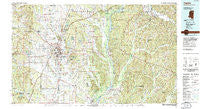
~ Tupelo MS topo map, 1:100000 scale, 30 X 60 Minute, Historical, 1984, updated 1985
Tupelo, Mississippi, USGS topographic map dated 1984.
Includes geographic coordinates (latitude and longitude). This topographic map is suitable for hiking, camping, and exploring, or framing it as a wall map.
Printed on-demand using high resolution imagery, on heavy weight and acid free paper, or alternatively on a variety of synthetic materials.
Topos available on paper, Waterproof, Poly, or Tyvek. Usually shipping rolled, unless combined with other folded maps in one order.
- Product Number: USGS-5599034
- Free digital map download (high-resolution, GeoPDF): Tupelo, Mississippi (file size: 36 MB)
- Map Size: please refer to the dimensions of the GeoPDF map above
- Weight (paper map): ca. 55 grams
- Map Type: POD USGS Topographic Map
- Map Series: HTMC
- Map Verison: Historical
- Cell ID: 68493
- Scan ID: 337241
- Imprint Year: 1985
- Woodland Tint: Yes
- Aerial Photo Year: 1983
- Edit Year: 1984
- Datum: NAD27
- Map Projection: Transverse Mercator
- Map published by United States Geological Survey
- Map published by Tennessee Valley Authority
- Map Language: English
- Scanner Resolution: 600 dpi
- Map Cell Name: Tupelo
- Grid size: 30 X 60 Minute
- Date on map: 1984
- Map Scale: 1:100000
- Geographical region: Mississippi, United States
Neighboring Maps:
All neighboring USGS topo maps are available for sale online at a variety of scales.
Spatial coverage:
Topo map Tupelo, Mississippi, covers the geographical area associated the following places:
- Tracewood - Wallerville - Bissell - Richmond - Sandy Springs - Blue Springs - New Bethel - Allyson Hills - Northwood Estates - Sharon Hills - Applewood - Ackia Gardens - Woodland - New Salem - Beacon Hill - Coggin Subdivision - Suburban Acres - Eastwood Place - Northwood Drive - Belledeer Hills - Camargo (historical) - Skyline - Harrisburg Heights - Alpine - Sherman - Lake Appaloosa Estates - Jordans Mill - Mantachie - Confederate Park - Clay - Beans Ferry - Ellistown - Horton Subdivision - Fairview - Livingston Subdivision - Priceville - Frog Island - Verona Heights - Lumpkin Subdivision - Poplar Springs - Palmetto - Prairie Mount (historical) - Wright Subdivision - Zion - Blair - Detroit - Wilemon - Parkway - Francis Subdivision - Pinehurst - Patterson Subdivision - Coleville (historical) - Terrace Park - Evergreen - Oakridge - Chiwapa - Haven Acres - Birmingham - Park Monceau - Rebecca Heights - Halltown - Shiloh - Nettleton - Eggville - Old Burleson - Vina - Lee Acres - Fawn Meadows - Lakeview - Van Buren - Centerville - Cedar Cove - Old Union - Lakewood Park - Boggan Grove - Shady Acres - Ballardsville - Hickory Flat (historical) - Hazeldell - Abney - Parks - Center - Plantersville - Fairfield - Fulton Bridge - Country Oak Estates - Poplar Springs - Branyan - Palmetto Estates - Bexar - Cadamy - Cherry Creek - Shannon - Madison Heights - Dorsey - Union - Bigbee - West Fulton - Chapelville - Pine Hill
- Map Area ID: AREA34.534-89-88
- Northwest corner Lat/Long code: USGSNW34.5-89
- Northeast corner Lat/Long code: USGSNE34.5-88
- Southwest corner Lat/Long code: USGSSW34-89
- Southeast corner Lat/Long code: USGSSE34-88
- Northern map edge Latitude: 34.5
- Southern map edge Latitude: 34
- Western map edge Longitude: -89
- Eastern map edge Longitude: -88


