
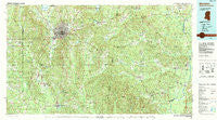
~ Meridian MS topo map, 1:100000 scale, 30 X 60 Minute, Historical, 1984, updated 1990
Meridian, Mississippi, USGS topographic map dated 1984.
Includes geographic coordinates (latitude and longitude). This topographic map is suitable for hiking, camping, and exploring, or framing it as a wall map.
Printed on-demand using high resolution imagery, on heavy weight and acid free paper, or alternatively on a variety of synthetic materials.
Topos available on paper, Waterproof, Poly, or Tyvek. Usually shipping rolled, unless combined with other folded maps in one order.
- Product Number: USGS-5599024
- Free digital map download (high-resolution, GeoPDF): Meridian, Mississippi (file size: 37 MB)
- Map Size: please refer to the dimensions of the GeoPDF map above
- Weight (paper map): ca. 55 grams
- Map Type: POD USGS Topographic Map
- Map Series: HTMC
- Map Verison: Historical
- Cell ID: 67943
- Scan ID: 337235
- Imprint Year: 1990
- Woodland Tint: Yes
- Visual Version Number: 1
- Aerial Photo Year: 1980
- Edit Year: 1984
- Datum: NAD27
- Map Projection: Universal Transverse Mercator
- Map published by United States Geological Survey
- Map Language: English
- Scanner Resolution: 600 dpi
- Map Cell Name: Meridian
- Grid size: 30 X 60 Minute
- Date on map: 1984
- Map Scale: 1:100000
- Geographical region: Mississippi, United States
Neighboring Maps:
All neighboring USGS topo maps are available for sale online at a variety of scales.
Spatial coverage:
Topo map Meridian, Mississippi, covers the geographical area associated the following places:
- Standard - White House (historical) - Arrington (historical) - Hurricane Creek - Devoe - Energy - Cromwell - Hookston - Linton - Robjohn - Ward - Complete - York - Stinson - Collinsville - East Enterprise - Lisman - Evergreen (historical) - Choctaw City - Indian Springs - Fellowship - Siloam - Lost Gap - Putnam - Snell - Sterling - Bonita - Robinson (historical) - Troy (historical) - Yantley - Zero - Kinterbish - Basic - Cliff Williams - Rock Springs - Pennington - Halsell - Arunde - Pine Ridge - Davidson (historical) - Oakchia - Riderwood - Stonewall - New Providence - Moseley - Hornsboro (historical) - Cuba - Coatopa - Middleton - Chunky - Bellamy - Sykes - Houston - Roy - Wautubbee - Meridian - Land - Increase - Derby - Savannah Grove - Gaston - Little Walker - Savoy - Duffee - Chapel Hill - Choctaw (historical) - Pine Springs - Tompkinsville - Lavaca - Hinton - Lockhart - Intercourse - Barrons (historical) - Pachuta - Mount Sterling - Edna - Perota (historical) - West Butler - Pleasant Hill - Jachin - Naheola - Scratch Hill - Cyril - Kewanee - Morgan Chapel - Enterprise - Dove - Rose Hill - West Enterprise - Poplar Springs - Orange - Bailey - Wolf Springs - Center Ridge - Williams - Green Acres - Beatrice - Mollie - Persimmon Grove - Shiloh
- Map Area ID: AREA32.532-89-88
- Northwest corner Lat/Long code: USGSNW32.5-89
- Northeast corner Lat/Long code: USGSNE32.5-88
- Southwest corner Lat/Long code: USGSSW32-89
- Southeast corner Lat/Long code: USGSSE32-88
- Northern map edge Latitude: 32.5
- Southern map edge Latitude: 32
- Western map edge Longitude: -89
- Eastern map edge Longitude: -88


