
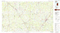
~ Laurel MS topo map, 1:100000 scale, 30 X 60 Minute, Historical, 1984, updated 1984
Laurel, Mississippi, USGS topographic map dated 1984.
Includes geographic coordinates (latitude and longitude). This topographic map is suitable for hiking, camping, and exploring, or framing it as a wall map.
Printed on-demand using high resolution imagery, on heavy weight and acid free paper, or alternatively on a variety of synthetic materials.
Topos available on paper, Waterproof, Poly, or Tyvek. Usually shipping rolled, unless combined with other folded maps in one order.
- Product Number: USGS-5599014
- Free digital map download (high-resolution, GeoPDF): Laurel, Mississippi (file size: 20 MB)
- Map Size: please refer to the dimensions of the GeoPDF map above
- Weight (paper map): ca. 55 grams
- Map Type: POD USGS Topographic Map
- Map Series: HTMC
- Map Verison: Historical
- Cell ID: 67827
- Scan ID: 337228
- Imprint Year: 1984
- Woodland Tint: Yes
- Aerial Photo Year: 1980
- Edit Year: 1984
- Datum: NAD27
- Map Projection: Universal Transverse Mercator
- Planimetric: Yes
- Map published by United States Geological Survey
- Map Language: English
- Scanner Resolution: 600 dpi
- Map Cell Name: Laurel
- Grid size: 30 X 60 Minute
- Date on map: 1984
- Map Scale: 1:100000
- Geographical region: Mississippi, United States
Neighboring Maps:
All neighboring USGS topo maps are available for sale online at a variety of scales.
Spatial coverage:
Topo map Laurel, Mississippi, covers the geographical area associated the following places:
- Service - Merit - Moss - Deen - Lanham - Silver Creek - Hoy - Martinville - Blue Ridge - Westville - Williamsburg - Zion Hill - Saratoga - Tawanta - Zion Hill - Providence - Hebron - Glaston - Seminary - Tuckers Crossing - Bethel - Cold Springs - Sanatorium - Whitesand - Shady Grove - Collins - Ellisville - Shivers - Stringer - Jenkins - Sand Hill - Upton - Kola - Matthews - McNair - Lone Star - Hopewell - Calhoun - Walters - Claiborne (historical) - Sharon - Markwald - Cleo - Benson - Eminence - Oak Bowery - Santee - Arbo - Amy - Terrell - Mineral Springs - Errata - Blakley Creek - Sandersville - Bezer - Glade - Boggan - Cyclone - New Haven - D'Lo - Gilmore - Gambrell - Oak Grove - Weathersby - Sunset - Gitano - Mendenhall - Carson - Oak Bowery (historical) - Jaynesville - Waldrup - McRaney - Springhill - Gandsi - Moselle - Antioch - Station Creek - Clem - Milton - Wisner - Pinola - Ora - Queensburg - Vennie Park - Friendship - Bush - Mount Olive - Haw Pond (historical) - Crotts - Tallahomo - Reddochs - Pendorff - Merry Hell - Union - New Hebron - Speedtown - Soso - Moscos - Mount Pleasant - Rock Hill
- Map Area ID: AREA3231.5-90-89
- Northwest corner Lat/Long code: USGSNW32-90
- Northeast corner Lat/Long code: USGSNE32-89
- Southwest corner Lat/Long code: USGSSW31.5-90
- Southeast corner Lat/Long code: USGSSE31.5-89
- Northern map edge Latitude: 32
- Southern map edge Latitude: 31.5
- Western map edge Longitude: -90
- Eastern map edge Longitude: -89


