
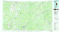
~ Kosciusko MS topo map, 1:100000 scale, 30 X 60 Minute, Historical, 1984
Kosciusko, Mississippi, USGS topographic map dated 1984.
Includes geographic coordinates (latitude and longitude). This topographic map is suitable for hiking, camping, and exploring, or framing it as a wall map.
Printed on-demand using high resolution imagery, on heavy weight and acid free paper, or alternatively on a variety of synthetic materials.
Topos available on paper, Waterproof, Poly, or Tyvek. Usually shipping rolled, unless combined with other folded maps in one order.
- Product Number: USGS-5599008
- Free digital map download (high-resolution, GeoPDF): Kosciusko, Mississippi (file size: 24 MB)
- Map Size: please refer to the dimensions of the GeoPDF map above
- Weight (paper map): ca. 55 grams
- Map Type: POD USGS Topographic Map
- Map Series: HTMC
- Map Verison: Historical
- Cell ID: 67777
- Scan ID: 337224
- Woodland Tint: Yes
- Visual Version Number: 1
- Aerial Photo Year: 1980
- Edit Year: 1984
- Datum: NAD27
- Map Projection: Universal Transverse Mercator
- Planimetric: Yes
- Map published by United States Geological Survey
- Map Language: English
- Scanner Resolution: 600 dpi
- Map Cell Name: Kosciusko
- Grid size: 30 X 60 Minute
- Date on map: 1984
- Map Scale: 1:100000
- Geographical region: Mississippi, United States
Neighboring Maps:
All neighboring USGS topo maps are available for sale online at a variety of scales.
Spatial coverage:
Topo map Kosciusko, Mississippi, covers the geographical area associated the following places:
- West Hill - McCool - Foltz - Reform - Thweatt (historical) - Cowpen (historical) - Rockport (historical) - Gum Springs - Doty Springs (historical) - Carmack - Berea (historical) - Marvins Chapel - Ford - Edgefield (historical) - Durant - Bowies Chapel - Poplar Creek - Langley (historical) - Estes - Hurricane - Sallis - Liberty Chapel - Poplar Springs - Tomnolen - Tabernacle (historical) - Vaiden - Beatty - Huntsville - Rural Hill - Antioch (historical) - Hendrix - Rome - Sturgis - Self Creek - Winona - Kosciusko - Hoffman - Tollison - Wood Springs - Glendale (historical) - Pleasant Ridge (historical) - Williams - Burkettsville (historical) - Boyette - Friendship (historical) - Springdale - Ethel - Pleasant Ridge - Gregory (historical) - Liberty Hill (historical) - Carson Ridge (historical) - Mount Herman - Aponaug (historical) - Edsville - Center Ridge - Earlyville - Sand Hill (historical) - Bugh - Weir - Chapel Hill (historical) - Joplin (historical) - Munson (historical) - Castalian Springs - Auris (historical) - Bowlin (historical) - Rocky Point - Forrest (historical) - Unity (historical) - Louisville - Attalaville (historical) - Dodds - Pierces Chapel - Mercer (historical) - Hinze - French Camp - Bowling Green - Providence - McMillan - Chita (historical) - Evergreen - Coila - Sherwood - Williamsville - Fentress - Steele (historical) - Pellez - East Macedonia - Plantation - Bluff Springs (historical) - Macedonia (historical) - Pilgrims Rest (historical) - Aberdeen Junction - New Hope (historical) - Kerr - Possumneck - Poplar Springs - Wiltshire - North Union (historical) - Owens Wells - Tuscan
- Map Area ID: AREA33.533-90-89
- Northwest corner Lat/Long code: USGSNW33.5-90
- Northeast corner Lat/Long code: USGSNE33.5-89
- Southwest corner Lat/Long code: USGSSW33-90
- Southeast corner Lat/Long code: USGSSE33-89
- Northern map edge Latitude: 33.5
- Southern map edge Latitude: 33
- Western map edge Longitude: -90
- Eastern map edge Longitude: -89


