
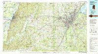
~ Jackson MS topo map, 1:100000 scale, 30 X 60 Minute, Historical, 1984, updated 1984
Jackson, Mississippi, USGS topographic map dated 1984.
Includes geographic coordinates (latitude and longitude). This topographic map is suitable for hiking, camping, and exploring, or framing it as a wall map.
Printed on-demand using high resolution imagery, on heavy weight and acid free paper, or alternatively on a variety of synthetic materials.
Topos available on paper, Waterproof, Poly, or Tyvek. Usually shipping rolled, unless combined with other folded maps in one order.
- Product Number: USGS-5599004
- Free digital map download (high-resolution, GeoPDF): Jackson, Mississippi (file size: 34 MB)
- Map Size: please refer to the dimensions of the GeoPDF map above
- Weight (paper map): ca. 55 grams
- Map Type: POD USGS Topographic Map
- Map Series: HTMC
- Map Verison: Historical
- Cell ID: 67723
- Scan ID: 337221
- Imprint Year: 1984
- Woodland Tint: Yes
- Aerial Photo Year: 1982
- Edit Year: 1984
- Datum: NAD27
- Map Projection: Universal Transverse Mercator
- Map published by United States Geological Survey
- Map Language: English
- Scanner Resolution: 600 dpi
- Map Cell Name: Jackson
- Grid size: 30 X 60 Minute
- Date on map: 1984
- Map Scale: 1:100000
- Geographical region: Mississippi, United States
Neighboring Maps:
All neighboring USGS topo maps are available for sale online at a variety of scales.
Spatial coverage:
Topo map Jackson, Mississippi, covers the geographical area associated the following places:
- Randall Place - East Manor Estates - Trailwood - Cedar Hill - Rosemary - Bradie - Vicksburg - Morgans Store - Terrapin Hill - Raymond - Green Crossing - Cayuga - Jetts - Great Lake Estates - Ingleside - Kimberly - Dogwood Place - Redwood - Carpenter - Creekwood Place - Roses Bluff - Byrd Heights - The Cascades - Mayfair - Gama - Shadow Lake Estates - Rolling Meadows - Cherry Park - Northwest Hills - Brookwood Pines - Simrall - Crossgates - Monterey - Western Hills - Le Tourneau - Dixon Acres - Brookwood - Highland Meadows - Lakeland - Carriage Hills - Woodville Heights - Rocky Springs - Humphreys - Homewood Manor Mobile Home Community - Northwoods - New Hope Grove - McRaven - Sherwood Forest - Brookleigh - Bolton - Forest Park Estates - Cleary - Northpointe - Warrenton - Green Acres - Bethesda - Sandalwood - Learned - Bernard - Pine Grove - Van Winkle - Skyway Hills - Brookhollow Place - Willowood - Luckney - Belaire - Clinton - Taylorsville - Timberlane - Seven Springs - Lake Ridgelea Subdivision - Village Square - Valley Mills - Byram - Raintree Place - Waltersville - Duke - Bellegrove - Bovina - Big Black - Rawhide - Cleary Heights - Cedar Hills - Lakeridge - Garden Park - Egypt Hill - Traceland North - Patton Place - Dabney Crossroads - The Breakers - Champion Hill - Lynchburg - Richmond (historical) - Melvin Heights - Wateroaks - Stonegate - Hope Springs - Country Woods - Timber Lakes - Lake Park
- Map Area ID: AREA32.532-91-90
- Northwest corner Lat/Long code: USGSNW32.5-91
- Northeast corner Lat/Long code: USGSNE32.5-90
- Southwest corner Lat/Long code: USGSSW32-91
- Southeast corner Lat/Long code: USGSSE32-90
- Northern map edge Latitude: 32.5
- Southern map edge Latitude: 32
- Western map edge Longitude: -91
- Eastern map edge Longitude: -90


