
~ Indianola MS topo map, 1:100000 scale, 30 X 60 Minute, Historical, 1994, updated 1994
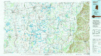
Indianola, Mississippi, USGS topographic map dated 1994.
Includes geographic coordinates (latitude and longitude). This topographic map is suitable for hiking, camping, and exploring, or framing it as a wall map.
Printed on-demand using high resolution imagery, on heavy weight and acid free paper, or alternatively on a variety of synthetic materials.
Topos available on paper, Waterproof, Poly, or Tyvek. Usually shipping rolled, unless combined with other folded maps in one order.
- Product Number: USGS-5599002
- Free digital map download (high-resolution, GeoPDF): Indianola, Mississippi (file size: 27 MB)
- Map Size: please refer to the dimensions of the GeoPDF map above
- Weight (paper map): ca. 55 grams
- Map Type: POD USGS Topographic Map
- Map Series: HTMC
- Map Verison: Historical
- Cell ID: 76807
- Scan ID: 337220
- Imprint Year: 1994
- Woodland Tint: Yes
- Aerial Photo Year: 1992
- Edit Year: 1994
- Datum: NAD27
- Map Projection: Universal Transverse Mercator
- Map published by United States Geological Survey
- Map Language: English
- Scanner Resolution: 600 dpi
- Map Cell Name: Indianola
- Grid size: 30 X 60 Minute
- Date on map: 1994
- Map Scale: 1:100000
- Geographical region: Mississippi, United States
Neighboring Maps:
All neighboring USGS topo maps are available for sale online at a variety of scales.
Spatial coverage:
Topo map Indianola, Mississippi, covers the geographical area associated the following places:
- Randolph (historical) - Meeks - Pine Grove - Hidi - Nelia (historical) - Geneill - Dunkirk - Spencer - Famosla - Good Hope - Mattoon - Stonewall - Acona - Oak Grove - Jones Crossing - Oklahoma - Blissdale - Swiftown - Magenta - Purnell - Castleman - Phillipstown - Quay (historical) - Morgan City - Richland - Inverness - Refuge - Franklin - Thornton - Darlove - Oregon - Gravel Hill - Holly Ridge - Rising Sun - Itta Bena - Bee Lake - Tribbett - Johnsonville - Egypt - Sheppardtown - Peteet - Vickland - Horseshoe - Lamkin - Romeo - Gum Grove - Burdette - Johnston - Centerville - Estill - Osseola - Brozville - Roseneath - Murdock Crossing - Nichols - Willet - Manhattan - Leland - Pluto - Murphy - Tchula - Mayday - Howard - Isola - Wyatt - McDaniels - McGrath - New Town - Overby - Cameta - Bourbon - Butler - Sidon - Markham - Omega - Muskedine - Choctaw - Black Hawk - Caile - Alder Grove (historical) - Quofaloma - Mileston - Dulweber - Tolarville - Milroy - Roebuck - Cletonia - Moorhead - Midnight - Westfield - Rexburg - Richey - Belle Prairie - Southside - Old Dominion - Empire - Tamburo (historical) - Hollyknowe - Heads - Ingrams
- Map Area ID: AREA33.533-91-90
- Northwest corner Lat/Long code: USGSNW33.5-91
- Northeast corner Lat/Long code: USGSNE33.5-90
- Southwest corner Lat/Long code: USGSSW33-91
- Southeast corner Lat/Long code: USGSSE33-90
- Northern map edge Latitude: 33.5
- Southern map edge Latitude: 33
- Western map edge Longitude: -91
- Eastern map edge Longitude: -90


