
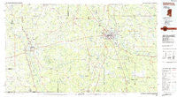
~ Hattiesburg MS topo map, 1:100000 scale, 30 X 60 Minute, Historical, 1984, updated 1984
Hattiesburg, Mississippi, USGS topographic map dated 1984.
Includes geographic coordinates (latitude and longitude). This topographic map is suitable for hiking, camping, and exploring, or framing it as a wall map.
Printed on-demand using high resolution imagery, on heavy weight and acid free paper, or alternatively on a variety of synthetic materials.
Topos available on paper, Waterproof, Poly, or Tyvek. Usually shipping rolled, unless combined with other folded maps in one order.
- Product Number: USGS-5598998
- Free digital map download (high-resolution, GeoPDF): Hattiesburg, Mississippi (file size: 21 MB)
- Map Size: please refer to the dimensions of the GeoPDF map above
- Weight (paper map): ca. 55 grams
- Map Type: POD USGS Topographic Map
- Map Series: HTMC
- Map Verison: Historical
- Cell ID: 72640
- Scan ID: 337217
- Imprint Year: 1984
- Woodland Tint: Yes
- Aerial Photo Year: 1981
- Edit Year: 1984
- Datum: NAD27
- Map Projection: Universal Transverse Mercator
- Planimetric: Yes
- Map published by United States Geological Survey
- Map Language: English
- Scanner Resolution: 600 dpi
- Map Cell Name: Hattiesburg
- Grid size: 30 X 60 Minute
- Date on map: 1984
- Map Scale: 1:100000
- Geographical region: Mississippi, United States
Neighboring Maps:
All neighboring USGS topo maps are available for sale online at a variety of scales.
Spatial coverage:
Topo map Hattiesburg, Mississippi, covers the geographical area associated the following places:
- Old Bassfield (historical) - Hurricane Creek - Seneca - Eastside - Petal - Petal Mobile Home Park - Kilsby Mobile Home Park - Eatonville - Saxon - Macedonia - Lamar Pines Mobile Home Community - Redhill - Lakewood - Bowie - Brooklyn - Richburg - Rawls Springs - New Augusta - Mars Hill - Pine Ridge - Regency Estates - Oak Grove - Sandy Hook - Sauer - Lux - Oloh - Newsom - Currie - Woodlawn Court - Jamestown - Lamar Park - Albeison - West Hattiesburg - Tallahala - Hub - Varnado - Four Points - Baxterville - Sumbax - Leeville - Epps - Hopewell - Ridgecrest Mobile Home Park - Harvey - Mahned - Sumrall - Wardwell - Sunrise - Columbia - Corinth - Bedford Woods - McCallum - Whitfield - R D Mobile Home Park - Wallis - Berkshire Hills - Ragland - Oak Vale - Forrest Hills - Pine Grove - Sanford - New Hope - Riverside - Expose - Pickwick - Innswood - Emmanuel - Hathorn - Rock Hill - Young Mobile Home Park - Barrontown - Pistol Ridge - Westgate - Lightville (historical) - Kirkwood Park - Shelton - Goss - Westwood - Morgantown - Purvis - Good Hope - Dragon - Ebenezer - Clyde - Bethel - West Hills - Wells Town - Bynum - Tall Pines - Dixie - Bonhomie - Breland - Harmony - Foxworth - Dexter - Wingate - Bunker Hill - Cheraw - Lake Serene South - Gay's Mobile Home Park
- Map Area ID: AREA31.531-90-89
- Northwest corner Lat/Long code: USGSNW31.5-90
- Northeast corner Lat/Long code: USGSNE31.5-89
- Southwest corner Lat/Long code: USGSSW31-90
- Southeast corner Lat/Long code: USGSSE31-89
- Northern map edge Latitude: 31.5
- Southern map edge Latitude: 31
- Western map edge Longitude: -90
- Eastern map edge Longitude: -89


