
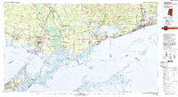
~ Gulfport MS topo map, 1:100000 scale, 30 X 60 Minute, Historical, 1982, updated 1983
Gulfport, Mississippi, USGS topographic map dated 1982.
Includes geographic coordinates (latitude and longitude). This topographic map is suitable for hiking, camping, and exploring, or framing it as a wall map.
Printed on-demand using high resolution imagery, on heavy weight and acid free paper, or alternatively on a variety of synthetic materials.
Topos available on paper, Waterproof, Poly, or Tyvek. Usually shipping rolled, unless combined with other folded maps in one order.
- Product Number: USGS-5598994
- Free digital map download (high-resolution, GeoPDF): Gulfport, Mississippi (file size: 27 MB)
- Map Size: please refer to the dimensions of the GeoPDF map above
- Weight (paper map): ca. 55 grams
- Map Type: POD USGS Topographic Map
- Map Series: HTMC
- Map Verison: Historical
- Cell ID: 67619
- Scan ID: 337214
- Imprint Year: 1983
- Woodland Tint: Yes
- Visual Version Number: 1
- Aerial Photo Year: 1979
- Edit Year: 1982
- Datum: NAD27
- Map Projection: Universal Transverse Mercator
- Map published by United States Geological Survey
- Map Language: English
- Scanner Resolution: 600 dpi
- Map Cell Name: Gulfport
- Grid size: 30 X 60 Minute
- Date on map: 1982
- Map Scale: 1:100000
- Geographical region: Mississippi, United States
Neighboring Maps:
All neighboring USGS topo maps are available for sale online at a variety of scales.
Spatial coverage:
Topo map Gulfport, Mississippi, covers the geographical area associated the following places:
- Bulah - Morgan Bluff - New Country Club - Eden Isle - Heritage Subdivision - Timber Lake Estates - Landon - Whisperwood Estates - Lindberg Glen - Smallwood Mobile Home Park - Travis Lott Mobile Home Park - Village de L'Est - Ozone Pines - Park Place - Napoleon - Royal Estates - Audubon - Crawford Landing - Ferncrest - Brookwood Estates - Cross Gates - Lake Forest - Twin Oaks Mobile Manor - North Shore Beach - Santa Rosa - Palm Lake - Nicholson - Salmen - Cypress Bay Mobile Home Park - Forest Pines - Westchester Estates - New Hope - Hickory Hills - Coalville - Dedeaux - Belvedere Estates - North End - Country Manor - Handsboro - Slidell - Nugent - Rigolets - West Hall Park - Pine Shadows - Bayou Vincent - North Side - Pinecrest - Southern Manor Mobile Home Park - Haaswood - Lake Gardens - South Point - Charleston Square - Slidell Ozone Heights - Brugier - Kingswood - Pine Forest - Barrington Park - Carolyn Park - Maude - Village North - Bayside Park - Liberty Pines - Wimbledon Estates - Hermedel - Saint Tammany - Woodlawn Acres - Christi Ann Lea - Flat Top - Bayou Paquet Estates - Hickory - Magnolia Heights - White Harbor - Amos - Porters River Landing - Kimberly Manor - Dream Courts Mobile Home Park - Regal Park Estates - Lake Catherine - Loraine - Shady Oak Mobile Park - Riverview Addition - Bayou Oaks - Timber Ridge - Big Branch - Chef Menteur - Adams Mobile Home Park - Vidalia Road Mobile Home Park - Wheel Inn Mobile Home Park - Lake Carmel - Tanglewood Village - Couves Mobile Home Park - Lakewood - Hidden Acres Mobile Home Park - The Settlement - Catahoula - Tamaron - Lincoln Park - White Kitchen - Bayou Terrace - Slidell Manor
- Map Area ID: AREA30.530-90-89
- Northwest corner Lat/Long code: USGSNW30.5-90
- Northeast corner Lat/Long code: USGSNE30.5-89
- Southwest corner Lat/Long code: USGSSW30-90
- Southeast corner Lat/Long code: USGSSE30-89
- Northern map edge Latitude: 30.5
- Southern map edge Latitude: 30
- Western map edge Longitude: -90
- Eastern map edge Longitude: -89


