
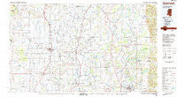
~ Greenwood MS topo map, 1:100000 scale, 30 X 60 Minute, Historical, 1983, updated 1983
Greenwood, Mississippi, USGS topographic map dated 1983.
Includes geographic coordinates (latitude and longitude). This topographic map is suitable for hiking, camping, and exploring, or framing it as a wall map.
Printed on-demand using high resolution imagery, on heavy weight and acid free paper, or alternatively on a variety of synthetic materials.
Topos available on paper, Waterproof, Poly, or Tyvek. Usually shipping rolled, unless combined with other folded maps in one order.
- Product Number: USGS-5598988
- Free digital map download (high-resolution, GeoPDF): Greenwood, Mississippi (file size: 24 MB)
- Map Size: please refer to the dimensions of the GeoPDF map above
- Weight (paper map): ca. 55 grams
- Map Type: POD USGS Topographic Map
- Map Series: HTMC
- Map Verison: Historical
- Cell ID: 67611
- Scan ID: 337210
- Imprint Year: 1983
- Woodland Tint: Yes
- Aerial Photo Year: 1976
- Edit Year: 1983
- Datum: NAD27
- Map Projection: Universal Transverse Mercator
- Map published by United States Geological Survey
- Map Language: English
- Scanner Resolution: 600 dpi
- Map Cell Name: Greenwood
- Grid size: 30 X 60 Minute
- Date on map: 1983
- Map Scale: 1:100000
- Geographical region: Mississippi, United States
Neighboring Maps:
All neighboring USGS topo maps are available for sale online at a variety of scales.
Spatial coverage:
Topo map Greenwood, Mississippi, covers the geographical area associated the following places:
- Steiner - Dahomy - Whitehead - Effie - Dwyer - Locopolis (historical) - Sumner - Lobdell - Albin - Quiver (historical) - O'Reilly - Drew - Fairview - Mound Bayou - Renova - Craigside - Symonds - Midway (historical) - Inwood - Wakeland - Waxhaw - Turner - Hatten - Black Bayou - Cleveland Crossing - Dwiggins - Skene - Brooks - Napanee - Crenfree - Paynes - Schlater - Waltonia (historical) - Wildwood - Distall - Grapeland - Sisloff Junction - Gill - Laughlin - Lombardy - Malmaison - Rixwood - Cottondale - Ballaston - Pace - Clifford - Leflore - Grenada Junction - Blue Lake - Cowart - Ruby - Black Bayou Junction - Valley Hill - McNutt - Whaley - Macel - Bright Corner - Christmas - Stephenville - Stringtown - Eastland - Gunnison - Sandy Bayou - Lehrton (historical) - Fort Loring - Cleveland - Whitney - Sharkey - Baltzer - Valley - Boyle - Powell Bayou - Ruleville - Wright - Somerville - Chocchuma (historical) - Minot - Niles - Teoc - White City - Dockery - Halstead - Pentecost - Frazier - Priscilla - Oxberry - Zumbro - Shellmound - Pine Land - Beulah - Linn - Swan Lake - Needmore (historical) - Litton - Choctaw - Doddsville - Mikoma - Wade (historical) - Minter City - Sunnyside
- Map Area ID: AREA3433.5-91-90
- Northwest corner Lat/Long code: USGSNW34-91
- Northeast corner Lat/Long code: USGSNE34-90
- Southwest corner Lat/Long code: USGSSW33.5-91
- Southeast corner Lat/Long code: USGSSE33.5-90
- Northern map edge Latitude: 34
- Southern map edge Latitude: 33.5
- Western map edge Longitude: -91
- Eastern map edge Longitude: -90


