
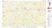
~ Forest MS topo map, 1:100000 scale, 30 X 60 Minute, Historical, 1984, updated 1984
Forest, Mississippi, USGS topographic map dated 1984.
Includes geographic coordinates (latitude and longitude). This topographic map is suitable for hiking, camping, and exploring, or framing it as a wall map.
Printed on-demand using high resolution imagery, on heavy weight and acid free paper, or alternatively on a variety of synthetic materials.
Topos available on paper, Waterproof, Poly, or Tyvek. Usually shipping rolled, unless combined with other folded maps in one order.
- Product Number: USGS-5598986
- Free digital map download (high-resolution, GeoPDF): Forest, Mississippi (file size: 20 MB)
- Map Size: please refer to the dimensions of the GeoPDF map above
- Weight (paper map): ca. 55 grams
- Map Type: POD USGS Topographic Map
- Map Series: HTMC
- Map Verison: Historical
- Cell ID: 67526
- Scan ID: 337209
- Imprint Year: 1984
- Woodland Tint: Yes
- Aerial Photo Year: 1981
- Edit Year: 1984
- Datum: NAD27
- Map Projection: Universal Transverse Mercator
- Planimetric: Yes
- Map published by United States Geological Survey
- Map Language: English
- Scanner Resolution: 600 dpi
- Map Cell Name: Forest
- Grid size: 30 X 60 Minute
- Date on map: 1984
- Map Scale: 1:100000
- Geographical region: Mississippi, United States
Neighboring Maps:
All neighboring USGS topo maps are available for sale online at a variety of scales.
Spatial coverage:
Topo map Forest, Mississippi, covers the geographical area associated the following places:
- Waterwood - Pine Lake - Jewells Hill (historical) - Bethel - Cooperville - Forest - Lorena - George (historical) - Fink Bine (historical) - Raworth - Mount Pleasant - Baxter - Cedar Grove - Goshen Springs - Okahta Talaia (historical) - Abernathy (historical) - Scanlon (historical) - East Hillsboro - Burns - Ebenezer - Kalem - Little Italy - Hunter Town - Toomer (historical) - Harperville - Johns - Pine Bluff - Conehatta - Chunky (historical) - Joe (historical) - Little Rock (historical) - Roscoe (historical) - Piketown - Easthaven - Cross Roads - Goodhope - Calhoun - Singleton Settlement - Forkville - Blounts Store - Urbo (historical) - Sylvarena - Wolf - Frogtown - Ball Hill - Dennis Settlement - Louin - Tallahoma (historical) - Galilee - Fannin - Ras - Traxler - Trenton - Lemon - McNeal - Tallow (historical) - Lawrence - Usrytown - Montrose - Bilbros Corner - Hazel - Verba - Holt (historical) - Lebanon - Gum Spring - Everett - Shiloh (historical) - Tanglewood - Braxton - Mayton - Fouke - Donohoe - Clifton - Mulberry - Fikestown - Moseley (historical) - Six Towns (historical) - Volcan (historical) - Cato - Dobson (historical) - Steele - Burns (historical) - Stratton - Pisgah - Sand Hill - Koch - Decatur - Hamlet (historical) - Stevens - Patrons Union (historical) - Lingle - Sun - West Leesburg - Rock Hill - Sherwood Forest - Garlandville - Pelahatchie - Hickory - Pilgrim Grove - Doolittle (historical)
- Map Area ID: AREA32.532-90-89
- Northwest corner Lat/Long code: USGSNW32.5-90
- Northeast corner Lat/Long code: USGSNE32.5-89
- Southwest corner Lat/Long code: USGSSW32-90
- Southeast corner Lat/Long code: USGSSE32-89
- Northern map edge Latitude: 32.5
- Southern map edge Latitude: 32
- Western map edge Longitude: -90
- Eastern map edge Longitude: -89


