
~ De Kalb MS topo map, 1:100000 scale, 30 X 60 Minute, Historical, 1984, updated 1990
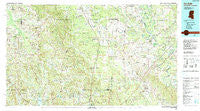
De Kalb, Mississippi, USGS topographic map dated 1984.
Includes geographic coordinates (latitude and longitude). This topographic map is suitable for hiking, camping, and exploring, or framing it as a wall map.
Printed on-demand using high resolution imagery, on heavy weight and acid free paper, or alternatively on a variety of synthetic materials.
Topos available on paper, Waterproof, Poly, or Tyvek. Usually shipping rolled, unless combined with other folded maps in one order.
- Product Number: USGS-5598980
- Free digital map download (high-resolution, GeoPDF): De Kalb, Mississippi (file size: 30 MB)
- Map Size: please refer to the dimensions of the GeoPDF map above
- Weight (paper map): ca. 55 grams
- Map Type: POD USGS Topographic Map
- Map Series: HTMC
- Map Verison: Historical
- Cell ID: 67390
- Scan ID: 337205
- Imprint Year: 1990
- Woodland Tint: Yes
- Aerial Photo Year: 1981
- Edit Year: 1984
- Datum: NAD27
- Map Projection: Universal Transverse Mercator
- Map published by United States Geological Survey
- Map Language: English
- Scanner Resolution: 600 dpi
- Map Cell Name: De Kalb
- Grid size: 30 X 60 Minute
- Date on map: 1984
- Map Scale: 1:100000
- Geographical region: Mississippi, United States
Neighboring Maps:
All neighboring USGS topo maps are available for sale online at a variety of scales.
Spatial coverage:
Topo map De Kalb, Mississippi, covers the geographical area associated the following places:
- Electric Mills - Zion Hill - Damascus - Texas (historical) - Old Scooba (historical) - East Coongetto (historical) - Crossroads - Martin - Epes - Giles - Mohegan (historical) - Millville - Calyx - Townsend - Claytown - Payneville - Scooba - Beckville (historical) - Vernon - Darnall (historical) - Gholson - Center Ridge (historical) - Cuthi Uckehaca (historical) - Shuqualak - Tamola - Oak Grove - Parker - Chomontakali (historical) - Cullum - Nanih Waiya - Bethel (historical) - Spinks (historical) - Miller - Obadiah - Boligee - Brewersville - East Abeika (historical) - Perdue - Blackwater - Red Bud (historical) - Binnsville - Old Wahalak (historical) - Oktibbeha (historical) - East Yazo Skatane (historical) - Hashuqua (historical) - Ayanabi (historical) - DeWeese - Coonwood (historical) - Warsaw - New Mount Hebron - New West Greene - Sledge - Cow Creek (historical) - West Greene - Emelle - Bond - Mount Nebo - Cleveland - Moscow - Gainesville - Holihtasha (historical) - Fowler - Bogue Chitto - Haanka Ullah (historical) - House - Rio - Forestdale - Fairhill - Lizelia - Peden (historical) - Bluff Springs - Liberty - Akron - Herbert (historical) - Geiger - Daleville - Crawford Fork - Herbert Springs - Rocky Mount (historical) - Lynville - Hatchette (historical) - Bluffport - Moore Town - Lizzieville - Paulette - Old Narkeetah (historical) - Kipling - Boyd - Kemper Springs - Preston - Bogue Toocolo Chitto (historical) - Summerville (historical) - Hamner - Hixon - Center Hill - Battlefield (historical) - Cooksville - Millington - Antioch (historical) - Porterville
- Map Area ID: AREA3332.5-89-88
- Northwest corner Lat/Long code: USGSNW33-89
- Northeast corner Lat/Long code: USGSNE33-88
- Southwest corner Lat/Long code: USGSSW32.5-89
- Southeast corner Lat/Long code: USGSSE32.5-88
- Northern map edge Latitude: 33
- Southern map edge Latitude: 32.5
- Western map edge Longitude: -89
- Eastern map edge Longitude: -88


