
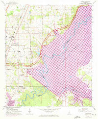
~ Madison MS topo map, 1:24000 scale, 7.5 X 7.5 Minute, Historical, 1963, updated 1972
Madison, Mississippi, USGS topographic map dated 1963.
Includes geographic coordinates (latitude and longitude). This topographic map is suitable for hiking, camping, and exploring, or framing it as a wall map.
Printed on-demand using high resolution imagery, on heavy weight and acid free paper, or alternatively on a variety of synthetic materials.
Topos available on paper, Waterproof, Poly, or Tyvek. Usually shipping rolled, unless combined with other folded maps in one order.
- Product Number: USGS-5596796
- Free digital map download (high-resolution, GeoPDF): Madison, Mississippi (file size: 16 MB)
- Map Size: please refer to the dimensions of the GeoPDF map above
- Weight (paper map): ca. 55 grams
- Map Type: POD USGS Topographic Map
- Map Series: HTMC
- Map Verison: Historical
- Cell ID: 27178
- Scan ID: 336052
- Imprint Year: 1972
- Woodland Tint: Yes
- Photo Revision Year: 1971
- Aerial Photo Year: 1971
- Field Check Year: 1963
- Datum: NAD27
- Map Projection: Polyconic
- Map published by United States Geological Survey
- Map Language: English
- Scanner Resolution: 600 dpi
- Map Cell Name: Madison
- Grid size: 7.5 X 7.5 Minute
- Date on map: 1963
- Map Scale: 1:24000
- Geographical region: Mississippi, United States
Neighboring Maps:
All neighboring USGS topo maps are available for sale online at a variety of scales.
Spatial coverage:
Topo map Madison, Mississippi, covers the geographical area associated the following places:
- Turtle Creek - North Town Plaza - Madison - Ashland Estates - Tidewater - Forest Point - Country Club Woods - Village Square - Tavern Hill - Woodlake - Treasure Cove - Millrun - Timber Lakes - Audubon Point - Sandalwood - Stonegate - Rolling Meadows - Lakeshore - Gateway North - Beaver Creek - Twin Harbor - Northpointe - Traceland North - Natchez Trace Village - Barnes Prairie - Roses Bluff - Pecan Creek - Village Glen - Arrowhead Point - The Breakers - Pelahatchie Woods - Hunters Creek - Paradise Point - Harbourview
- Map Area ID: AREA32.532.375-90.125-90
- Northwest corner Lat/Long code: USGSNW32.5-90.125
- Northeast corner Lat/Long code: USGSNE32.5-90
- Southwest corner Lat/Long code: USGSSW32.375-90.125
- Southeast corner Lat/Long code: USGSSE32.375-90
- Northern map edge Latitude: 32.5
- Southern map edge Latitude: 32.375
- Western map edge Longitude: -90.125
- Eastern map edge Longitude: -90


