
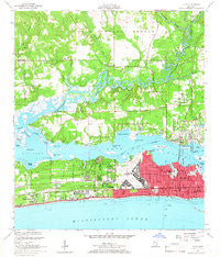
~ Biloxi MS topo map, 1:24000 scale, 7.5 X 7.5 Minute, Historical, 1954, updated 1966
Biloxi, Mississippi, USGS topographic map dated 1954.
Includes geographic coordinates (latitude and longitude). This topographic map is suitable for hiking, camping, and exploring, or framing it as a wall map.
Printed on-demand using high resolution imagery, on heavy weight and acid free paper, or alternatively on a variety of synthetic materials.
Topos available on paper, Waterproof, Poly, or Tyvek. Usually shipping rolled, unless combined with other folded maps in one order.
- Product Number: USGS-5595438
- Free digital map download (high-resolution, GeoPDF): Biloxi, Mississippi (file size: 11 MB)
- Map Size: please refer to the dimensions of the GeoPDF map above
- Weight (paper map): ca. 55 grams
- Map Type: POD USGS Topographic Map
- Map Series: HTMC
- Map Verison: Historical
- Cell ID: 3941
- Scan ID: 335351
- Imprint Year: 1966
- Woodland Tint: Yes
- Aerial Photo Year: 1950
- Field Check Year: 1954
- Survey Year: 1952
- Datum: NAD27
- Map Projection: Polyconic
- Map published by United States Geological Survey
- Map published by United States Department of Commerce
- Map Language: English
- Scanner Resolution: 600 dpi
- Map Cell Name: Biloxi
- Grid size: 7.5 X 7.5 Minute
- Date on map: 1954
- Map Scale: 1:24000
- Geographical region: Mississippi, United States
Neighboring Maps:
All neighboring USGS topo maps are available for sale online at a variety of scales.
Spatial coverage:
Topo map Biloxi, Mississippi, covers the geographical area associated the following places:
- Ridgeland Mobile Home Park - Woodridge Estates Mobile Home Park - Rolling Hills Mobile Estates - Biloxi - Imperial Mobile Estates - Wool Market - De Buys - Cedar Lake - D'Iberville - Cedar Lake Mobile Home Village - Blairs Trailer Park - Pine Grove Mobile Home Park - Parkers Mobile Home Park - Country Living Mobile Home Village - Heartease (historical) - Rolling Heights Mobile Estates - Starlite Mobile Home Park - Hidden River Mobile Ranch - North Biloxi - Bud's Mobile Park - Oberts Mobile Park - Wool Market Mobile Home Park - Edgewater Park - Beauvoir - B and H Mobile Home Park - Oaklawn Mobile Home Park - Apple Valley Mobile Park - Pine Haven Mobile Home Village - Century Oaks Retirement Community Mobile Home Park - Sherwood Village Mobile Home Park - Bay Shore Mobile Court
- Map Area ID: AREA30.530.375-89-88.875
- Northwest corner Lat/Long code: USGSNW30.5-89
- Northeast corner Lat/Long code: USGSNE30.5-88.875
- Southwest corner Lat/Long code: USGSSW30.375-89
- Southeast corner Lat/Long code: USGSSE30.375-88.875
- Northern map edge Latitude: 30.5
- Southern map edge Latitude: 30.375
- Western map edge Longitude: -89
- Eastern map edge Longitude: -88.875


