
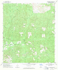
~ Baxterville NE MS topo map, 1:24000 scale, 7.5 X 7.5 Minute, Historical, 1969, updated 1971
Baxterville NE, Mississippi, USGS topographic map dated 1969.
Includes geographic coordinates (latitude and longitude). This topographic map is suitable for hiking, camping, and exploring, or framing it as a wall map.
Printed on-demand using high resolution imagery, on heavy weight and acid free paper, or alternatively on a variety of synthetic materials.
Topos available on paper, Waterproof, Poly, or Tyvek. Usually shipping rolled, unless combined with other folded maps in one order.
- Product Number: USGS-5595318
- Free digital map download (high-resolution, GeoPDF): Baxterville NE, Mississippi (file size: 12 MB)
- Map Size: please refer to the dimensions of the GeoPDF map above
- Weight (paper map): ca. 55 grams
- Map Type: POD USGS Topographic Map
- Map Series: HTMC
- Map Verison: Historical
- Cell ID: 2692
- Scan ID: 335293
- Imprint Year: 1971
- Woodland Tint: Yes
- Aerial Photo Year: 1967
- Field Check Year: 1969
- Datum: NAD27
- Map Projection: Polyconic
- Map published by United States Geological Survey
- Map Language: English
- Scanner Resolution: 600 dpi
- Map Cell Name: Baxterville NE
- Grid size: 7.5 X 7.5 Minute
- Date on map: 1969
- Map Scale: 1:24000
- Geographical region: Mississippi, United States
Neighboring Maps:
All neighboring USGS topo maps are available for sale online at a variety of scales.
Spatial coverage:
Topo map Baxterville NE, Mississippi, covers the geographical area associated the following places:
- Beaver Dam Creek - Hurricane Creek - Lamar County - Little Bay Creek - Bay Creek Church - Sweetwater Branch - Big Branch - East Gully Creek - Jacks Creek - Gall Berry Brake - York S Lake Dam - Southwest Lamar Volunteer Fire Department Station 2 - Clear Spring Branch - Caney Church - Beaver Pond Branch - Blue Springs Branch - Spice Pond Creek - Half Moon Creek - Lamar Lookout Tower - Greenville Church - Buck Branch - Tatums Camps - Wolf Branch - Gum Reed Brake - Bay Creek - Driven Branch - Grantham Creek - Alec Prong - Hickory Hollow - Bay Creek Cemetery - Mill Branch - Bondity Ponds Branch - Big Thick Creek - Burnt School (historical)
- Map Area ID: AREA31.2531.125-89.625-89.5
- Northwest corner Lat/Long code: USGSNW31.25-89.625
- Northeast corner Lat/Long code: USGSNE31.25-89.5
- Southwest corner Lat/Long code: USGSSW31.125-89.625
- Southeast corner Lat/Long code: USGSSE31.125-89.5
- Northern map edge Latitude: 31.25
- Southern map edge Latitude: 31.125
- Western map edge Longitude: -89.625
- Eastern map edge Longitude: -89.5


