
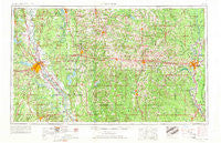
~ Shreveport LA topo map, 1:250000 scale, 1 X 2 Degree, Historical, 1955, updated 1966
Shreveport, Louisiana, USGS topographic map dated 1955.
Includes geographic coordinates (latitude and longitude). This topographic map is suitable for hiking, camping, and exploring, or framing it as a wall map.
Printed on-demand using high resolution imagery, on heavy weight and acid free paper, or alternatively on a variety of synthetic materials.
Topos available on paper, Waterproof, Poly, or Tyvek. Usually shipping rolled, unless combined with other folded maps in one order.
- Product Number: USGS-5595190
- Free digital map download (high-resolution, GeoPDF): Shreveport, Louisiana (file size: 20 MB)
- Map Size: please refer to the dimensions of the GeoPDF map above
- Weight (paper map): ca. 55 grams
- Map Type: POD USGS Topographic Map
- Map Series: HTMC
- Map Verison: Historical
- Cell ID: 69030
- Scan ID: 335226
- Imprint Year: 1966
- Woodland Tint: Yes
- Aerial Photo Year: 1952
- Edit Year: 1966
- Field Check Year: 1955
- Datum: Unstated
- Map Projection: Transverse Mercator
- Map published by United States Army
- Map Language: English
- Scanner Resolution: 600 dpi
- Map Cell Name: Shreveport
- Grid size: 1 X 2 Degree
- Date on map: 1955
- Map Scale: 1:250000
- Geographical region: Louisiana, United States
Neighboring Maps:
All neighboring USGS topo maps are available for sale online at a variety of scales.
Spatial coverage:
Topo map Shreveport, Louisiana, covers the geographical area associated the following places:
- Hughes - Laran - Cedar Grove - Haynesville - Plain Dealing - Burgessville (historical) - Sibley - Merrywoods - Brewtons Mill - Taylortown - Steven - Oil City - Treasure Island - Shongaloo - Brownlee Estates - McIntyre - Wildwood South - Mayers - Holly Springs - Lake Hayes - Pine Grove - Ebenezer - Hunt - Mooringsport - Bienville - Elmwood (historical) - Old Athens - Cross Roads - Atkins - Alden Bridge - Mimosa Gardens - Lamkin - New Hope - Bemis - Pace - Spring Ridge - Meadow Creek Subdivision - Highland Park - Mount Pleasant - Shenandoah - Loe - Green Terrace - Dodson - Robson - Forest Grove - Holmesville - Hillside Park - Scottsville - Hodge - Kline - Phillips - Thirteen Points Landing - McKenzie - Lucas - La Mesa - Evergreen - Bosco - Staples - Century Park - Spring Lake Estates - Green Springs - Burkplace - Poole - Eros - Mot - Pleasant Hill - Hadley - South Merrywoods - Swindleville - Dorian Terrace - Fords - Linton - Westdale - Hinkle - Marion - Southern Hills - Upco - Curtis - Logtown - Tama - Suburban North - Garden Park - Northpark Village - Northwood Estates - Spring Hill - Timothy (historical) - Minden - Briarcliff - Arlatex - Pine Grove - Hall Summit - Fairbanks - Carriage Oaks - Audrey Park - Wildwood - Kings Oaks - Winona (historical) - Shadow Pine Estates - Rilla - Oshkosh (historical)
- Map Area ID: AREA3332-94-92
- Northwest corner Lat/Long code: USGSNW33-94
- Northeast corner Lat/Long code: USGSNE33-92
- Southwest corner Lat/Long code: USGSSW32-94
- Southeast corner Lat/Long code: USGSSE32-92
- Northern map edge Latitude: 33
- Southern map edge Latitude: 32
- Western map edge Longitude: -94
- Eastern map edge Longitude: -92


