
~ New Orleans LA topo map, 1:250000 scale, 1 X 2 Degree, Historical, 1945
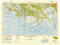
New Orleans, Louisiana, USGS topographic map dated 1945.
Includes geographic coordinates (latitude and longitude). This topographic map is suitable for hiking, camping, and exploring, or framing it as a wall map.
Printed on-demand using high resolution imagery, on heavy weight and acid free paper, or alternatively on a variety of synthetic materials.
Topos available on paper, Waterproof, Poly, or Tyvek. Usually shipping rolled, unless combined with other folded maps in one order.
- Product Number: USGS-5595180
- Free digital map download (high-resolution, GeoPDF): New Orleans, Louisiana (file size: 23 MB)
- Map Size: please refer to the dimensions of the GeoPDF map above
- Weight (paper map): ca. 55 grams
- Map Type: POD USGS Topographic Map
- Map Series: HTMC
- Map Verison: Historical
- Cell ID: 72240
- Scan ID: 335221
- Woodland Tint: Yes
- Aerial Photo Year: 1945
- Datum: NAD27
- Map Projection: Transverse Mercator
- Planimetric: Yes
- Map published by United States Army
- Map Language: English
- Scanner Resolution: 600 dpi
- Map Cell Name: New Orleans
- Grid size: 1 X 2 Degree
- Date on map: 1945
- Map Scale: 1:250000
- Geographical region: Louisiana, United States
Neighboring Maps:
All neighboring USGS topo maps are available for sale online at a variety of scales.
Spatial coverage:
Topo map New Orleans, Louisiana, covers the geographical area associated the following places:
- Norbert - Elmfield - United - Myrtle Grove (historical) - Batree - Dwight Fields - Camardelle - Brousville - Live Oak Manor - Raceland - Choupique - Good Hope - Ama - Salix - Oak Forest - Mobile Estates Mobile Home Park - Olivier - Houma - Ellendale - Twelve Cedars - Choctaw - Taft - Magnolia - Florence - Mobile Home Park - Bertie - Bowie - Thibodaux - Tree Lawn Trailer Court - Oak Alley - Bellewood - Cancienne - Willswood - Norco - Faith Trailer Court - Davis (historical) - Marce - Pricetown (historical) - Green Acres - Bon Secours Plantation - Gray - Cote Blanche Landing - Brusle Saint Vincent - Avoca - Live Oak - Hahnville - Lower Texas - Migues - Harvey - Bobtown - Beverly Knoll - Shrewsbury - Adeline - Oak Ridge Park - Hope - Carrollton - Morvant - Luke Landing - Greewood Plantation - Jefferson Island - Pines Lane Mobile Home Park - Gibson - Cefalu Mobile Home Park - Wyandotte - Siracusaville - Tabatiere Perdue - Schriever - Woodmere - Justice Trailer Court - Charlies Mobile Home Village - Saint James Plantation - Faubourg Marigny - Saint Rose Plantation - Bessie K - Marrero - Mott Trailer Park - Madewood - Greenwood - New Hope (historical) - Violas Mobile Home Park - Concession - Foley - Englewood - Jean Lafitte - Jeanerette - Armant - Paincourtville - Georgia - Leleux - Country Boy Mobile Home Park - Brule - Mathews - Jay - North Vacherie - Webre Steib Plantation - Lewistown - Ursa - Richland - Dulac - Promised Land
- Map Area ID: AREA3029-92-90
- Northwest corner Lat/Long code: USGSNW30-92
- Northeast corner Lat/Long code: USGSNE30-90
- Southwest corner Lat/Long code: USGSSW29-92
- Southeast corner Lat/Long code: USGSSE29-90
- Northern map edge Latitude: 30
- Southern map edge Latitude: 29
- Western map edge Longitude: -92
- Eastern map edge Longitude: -90


