
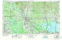
~ Baton Rouge LA topo map, 1:250000 scale, 1 X 2 Degree, Historical, 1954, updated 1974
Baton Rouge, Louisiana, USGS topographic map dated 1954.
Includes geographic coordinates (latitude and longitude). This topographic map is suitable for hiking, camping, and exploring, or framing it as a wall map.
Printed on-demand using high resolution imagery, on heavy weight and acid free paper, or alternatively on a variety of synthetic materials.
Topos available on paper, Waterproof, Poly, or Tyvek. Usually shipping rolled, unless combined with other folded maps in one order.
- Product Number: USGS-5595170
- Free digital map download (high-resolution, GeoPDF): Baton Rouge, Louisiana (file size: 21 MB)
- Map Size: please refer to the dimensions of the GeoPDF map above
- Weight (paper map): ca. 55 grams
- Map Type: POD USGS Topographic Map
- Map Series: HTMC
- Map Verison: Historical
- Cell ID: 68664
- Scan ID: 335212
- Imprint Year: 1974
- Woodland Tint: Yes
- Visual Version Number: 1
- Aerial Photo Year: 1971
- Edit Year: 1972
- Field Check Year: 1954
- Datum: Unstated
- Map Projection: Transverse Mercator
- Map published by United States Army
- Map Language: English
- Scanner Resolution: 600 dpi
- Map Cell Name: Baton Rouge
- Grid size: 1 X 2 Degree
- Date on map: 1954
- Map Scale: 1:250000
- Geographical region: Louisiana, United States
Neighboring Maps:
All neighboring USGS topo maps are available for sale online at a variety of scales.
Spatial coverage:
Topo map Baton Rouge, Louisiana, covers the geographical area associated the following places:
- Longwood Court - Independence Place - Shexnayder - University Place - Geary (historical) - Prestige Place Mobile Home Park - Liverpool - Mestayer - Greenwell Springs - Ted Davis Mobile Home Park - Howell - Sweetbriar - River Oaks - Saint Francisville - Jones Creek - Haydel (historical) - Alford Acres - Oak Hills - Cress (historical) - Legonier - Slaughter - Fairwoods - North Pass - Rhodes - Immaculata - Shamrock Plaza - Brookstown - Grosse Tete - Marathon - Independence - Willis - North Maryland - Danks - Ballards Mobile Home Park - University Place - Denham Springs - Paulina - Bristol - Rosebank - Turnbull - Gypsy - Briar Place - Rosaryville - Comite - Aubin - Plettenberg - Land O'Lakes - Landon Mobile Home Park - Segura - Keller - Burlington (historical) - Harwich - Portage - Lobdell Station - Grand Bayou - Saint Pius Place - Tunica - Central - Bayou Goula - Mount Airy - Highland Estates - Scotland - Pinewood Acres - Greenwell Acres East - Westchester - Chenango - Rougon - Palmetto Mobile Home Park - Ulyssee - Martinville - Bluebonnet Ridge - Bonaire Estates - Winchester - Holiday Woods - Rushmore - Lake Terrace - Mirabeau Gardens - Quail Ridge - Houltonville - Ruddock - Heatherstone - Iberville - Lincoln Heights - Purvis (historical) - Bushville - Dutch Bayou - Natalbany - Baywood - Red Oak - Billeaud - North Red Oaks - Allemania - Saint Louis - Town and Country Mobile Home Village - Corbin - B and K Mobile Park - Baker Estates - Terra Haute - Bonn - Poplar Grove Plantation
- Map Area ID: AREA3130-92-90
- Northwest corner Lat/Long code: USGSNW31-92
- Northeast corner Lat/Long code: USGSNE31-90
- Southwest corner Lat/Long code: USGSSW30-92
- Southeast corner Lat/Long code: USGSSE30-90
- Northern map edge Latitude: 31
- Southern map edge Latitude: 30
- Western map edge Longitude: -92
- Eastern map edge Longitude: -90


