
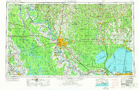
~ Baton Rouge LA topo map, 1:250000 scale, 1 X 2 Degree, Historical, 1954, updated 1974
Baton Rouge, Louisiana, USGS topographic map dated 1954.
Includes geographic coordinates (latitude and longitude). This topographic map is suitable for hiking, camping, and exploring, or framing it as a wall map.
Printed on-demand using high resolution imagery, on heavy weight and acid free paper, or alternatively on a variety of synthetic materials.
Topos available on paper, Waterproof, Poly, or Tyvek. Usually shipping rolled, unless combined with other folded maps in one order.
- Product Number: USGS-5595168
- Free digital map download (high-resolution, GeoPDF): Baton Rouge, Louisiana (file size: 21 MB)
- Map Size: please refer to the dimensions of the GeoPDF map above
- Weight (paper map): ca. 55 grams
- Map Type: POD USGS Topographic Map
- Map Series: HTMC
- Map Verison: Historical
- Cell ID: 68664
- Scan ID: 335211
- Imprint Year: 1974
- Woodland Tint: Yes
- Aerial Photo Year: 1972
- Edit Year: 1972
- Field Check Year: 1954
- Datum: Unstated
- Map Projection: Transverse Mercator
- Map published by United States Army
- Map Language: English
- Scanner Resolution: 600 dpi
- Map Cell Name: Baton Rouge
- Grid size: 1 X 2 Degree
- Date on map: 1954
- Map Scale: 1:250000
- Geographical region: Louisiana, United States
Neighboring Maps:
All neighboring USGS topo maps are available for sale online at a variety of scales.
Spatial coverage:
Topo map Baton Rouge, Louisiana, covers the geographical area associated the following places:
- Sharon Hills - Beaud - Belle Alliance - Riddle - Court Street Estates Mobile Home Park - Acadiana - Bolwood Acres - Huron - Acy - Prestige Place Mobile Home Park - South Broadmoor - Indian Beach - Oak Park - Windfall - Oak Forest - East Ridgewood - Whiskey Lane Mobile Home Park - Kildare - Northeast Place - Tunica - Walnut Hill - Burke - Sandy's Trailer Park - Uneedus - Katie (historical) - Miles - Bellingrath Hills - Cedar Glen - Saint John - University Terrace - Brake - Slacks - Enon - Wayside (historical) - Round Oak - Lynwood Village - Argyle - Monte Sano Trailer Park - Brightside Park - Troy (historical) - Seabrook - Delacroix - Monhegan - Hundred Oaks - Hazel (historical) - Haydel (historical) - Hatchersville - Philadelphia Point - Pelba - Mengel Landing - Zee Zee Gardens - Bayou Goula - Darbonne - Golden Ridge - Bernard Terrace - Sunrise - Maribel Village - Oldfield - Sorrento - Saint Elmo - Westdale Heights - South Dayton - McGehee (historical) - Montz - Lobdell Station - Ventress - Cypress Creek Mobile Home Court - Bruces Mobile Home Park - Maxies Mobile Valley - Island - Lukeville - Bridlewood - Marburyville (historical) - McHugh - Sweetbriar - Jordan Terrace - Evergreen Plantation - Perkins Village - Comite Hills - Hopeville (historical) - Cofield - Belle Place Trailer Park - Texas - Forest Oaks - Bruly Saint Martin - Eden Church Road Mobile Park - Hope Villa - Grand Bayou - Alma - Inniswold Estates - Woods Edge - Ruddock - Husser - Terra Haute - Orr (historical) - Saint Elmo - Morbihan - Milneburg - Parkwood Terrace - Forest Heights Park
- Map Area ID: AREA3130-92-90
- Northwest corner Lat/Long code: USGSNW31-92
- Northeast corner Lat/Long code: USGSNE31-90
- Southwest corner Lat/Long code: USGSSW30-92
- Southeast corner Lat/Long code: USGSSE30-90
- Northern map edge Latitude: 31
- Southern map edge Latitude: 30
- Western map edge Longitude: -92
- Eastern map edge Longitude: -90


