
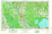
~ Baton Rouge LA topo map, 1:250000 scale, 1 X 2 Degree, Historical, 1961, updated 1966
Baton Rouge, Louisiana, USGS topographic map dated 1961.
Includes geographic coordinates (latitude and longitude). This topographic map is suitable for hiking, camping, and exploring, or framing it as a wall map.
Printed on-demand using high resolution imagery, on heavy weight and acid free paper, or alternatively on a variety of synthetic materials.
Topos available on paper, Waterproof, Poly, or Tyvek. Usually shipping rolled, unless combined with other folded maps in one order.
- Product Number: USGS-5595164
- Free digital map download (high-resolution, GeoPDF): Baton Rouge, Louisiana (file size: 19 MB)
- Map Size: please refer to the dimensions of the GeoPDF map above
- Weight (paper map): ca. 55 grams
- Map Type: POD USGS Topographic Map
- Map Series: HTMC
- Map Verison: Historical
- Cell ID: 68664
- Scan ID: 335209
- Imprint Year: 1966
- Woodland Tint: Yes
- Aerial Photo Year: 1954
- Field Check Year: 1954
- Datum: Unstated
- Map Projection: Transverse Mercator
- Map published by United States Geological Survey
- Map published by United States Army
- Map Language: English
- Scanner Resolution: 600 dpi
- Map Cell Name: Baton Rouge
- Grid size: 1 X 2 Degree
- Date on map: 1961
- Map Scale: 1:250000
- Geographical region: Louisiana, United States
Neighboring Maps:
All neighboring USGS topo maps are available for sale online at a variety of scales.
Spatial coverage:
Topo map Baton Rouge, Louisiana, covers the geographical area associated the following places:
- S and R Mobile Home Park - Mitchell - Pecan Cove - Walls - Tigerland Acres - Twin Lakes Mobile Estates - Morbihan - Somers (historical) - Sherwood Forest - Moreco - Raccourci (historical) - Quail Run - Sarasota Place - Kin Tally - Baton Rouge Terrace - Nott (historical) - Bolden - Tara - Coleman Town - Westover - Barroza (historical) - Lobdell Station - Sharlo - Shenandoah - Fulda (historical) - University Place - Terra Haute - Greenlaw - Catherine - Malarcher (historical) - Teddy - Inniswold - Cajun Country Mobile Home Park - Hackley - Riverland - Bat - Tunica Landing - Carmen Terrace - Orr (historical) - South Baton Rouge - Darlington - Round Oak - Indian Park - Oak Hills Place - Magnolia Woods - Country Estate Acres - Woodland View - Garyville - Liverpool - Bougere (historical) - Patin - Dougherty Place - Pontchartrain Gardens - Sherwood Garden Homes - Plantation Trace - Shadowbrook - Eastover Estates Mobile Home Park - Cedar Glen - Frozard - South Bilt - Northdale - Saint Amant - Dent Terrace - Angola - Pine Park - Southern Mobile Home Park - South River Oaks - Brulie Maurin - Phillipston (historical) - Waterloo - White Hills - Westdale Heights - Bobby Lejeune Mobile Home Park - Sunshine - Lake Forest Park - Miles - Jacoby - Gardere - Devalls - Irene - Sweet Home - University Acres - Gentilly Woods - Little Lake Estates Mobile Home Park - Cypress Creek Mobile Home Court - Highland Road Estates - The Myrtles - Aubin - Whispering Oaks - Highlandia - Frisco (historical) - Independent - Port Barre - Oak Forest Mobile Home Park - North Red Oaks - Timberton (historical) - Evergreen Hills - Walet - Bayou Corne - Ski Stone
- Map Area ID: AREA3130-92-90
- Northwest corner Lat/Long code: USGSNW31-92
- Northeast corner Lat/Long code: USGSNE31-90
- Southwest corner Lat/Long code: USGSSW30-92
- Southeast corner Lat/Long code: USGSSE30-90
- Northern map edge Latitude: 31
- Southern map edge Latitude: 30
- Western map edge Longitude: -92
- Eastern map edge Longitude: -90


