
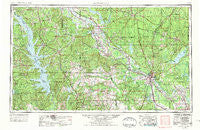
~ Alexandria LA topo map, 1:250000 scale, 1 X 2 Degree, Historical, 1953, updated 1975
Alexandria, Louisiana, USGS topographic map dated 1953.
Includes geographic coordinates (latitude and longitude). This topographic map is suitable for hiking, camping, and exploring, or framing it as a wall map.
Printed on-demand using high resolution imagery, on heavy weight and acid free paper, or alternatively on a variety of synthetic materials.
Topos available on paper, Waterproof, Poly, or Tyvek. Usually shipping rolled, unless combined with other folded maps in one order.
- Product Number: USGS-5595160
- Free digital map download (high-resolution, GeoPDF): Alexandria, Louisiana (file size: 22 MB)
- Map Size: please refer to the dimensions of the GeoPDF map above
- Weight (paper map): ca. 55 grams
- Map Type: POD USGS Topographic Map
- Map Series: HTMC
- Map Verison: Historical
- Cell ID: 68641
- Scan ID: 335207
- Imprint Year: 1975
- Woodland Tint: Yes
- Visual Version Number: 1
- Aerial Photo Year: 1972
- Edit Year: 1973
- Field Check Year: 1953
- Datum: Unstated
- Map Projection: Transverse Mercator
- Map published by United States Army
- Map Language: English
- Scanner Resolution: 600 dpi
- Map Cell Name: Alexandria
- Grid size: 1 X 2 Degree
- Date on map: 1953
- Map Scale: 1:250000
- Geographical region: Louisiana, United States
Neighboring Maps:
All neighboring USGS topo maps are available for sale online at a variety of scales.
Spatial coverage:
Topo map Alexandria, Louisiana, covers the geographical area associated the following places:
- Magnolia - Mora - Witchwood (historical) - Tannehill - Carla - Lake End - Lee Hills - Sexton - Hicks - Whitford - Chambers - Manistee (historical) - Oklahoma - Mayflower - Hickory Ridge - Little Creek - Logansport - Urania - Beech (historical) - Cypress - Everett (historical) - Calvert Acres - Piermont - Black Creek (historical) - Florien - Nicks (historical) - Smithville - Vowells Mill - Pineville Junction - Hemphill - Leesville - Mount Zion - Rock - Melrose - Tide (historical) - Paragon (historical) - Rogers - Clyde - Midway - Hagewood - Pelican - Hanna - Clarence - Shamard Heights - Kadesh - Gandy - Dolette (historical) - Iatt - Dobs Crossing - Hornbeck - Spider (historical) - Point Place - Cooley - Lacamp - Muse (historical) - Saint Maurice - Lincecum - Kincaid (historical) - Blade - Zenoria - Grove Hill - Alexandria - Isla - Hobson (historical) - Westlake - Shady Oaks - Marthaville - Recknor (historical) - Summerville - Rochelle - Reynolds - Sampusand - Bayou Scie - Rock Hill - Simpson - Nickel - South Toledo Bend - Zion - Valde Rouge (historical) - Magnolia Park - Nugent - Sand Spur - McElroy - Clifton Crossing - Simms - Quadrate - Pleasant Hill - Dry Prong - McFarland Heights - Bijou - Alliance - Coburn - Camp Hardtner - Hatfield - Corleyville - Jordan Hill - Antonia - Noble - Breedlove Hills - West End
- Map Area ID: AREA3231-94-92
- Northwest corner Lat/Long code: USGSNW32-94
- Northeast corner Lat/Long code: USGSNE32-92
- Southwest corner Lat/Long code: USGSSW31-94
- Southeast corner Lat/Long code: USGSSE31-92
- Northern map edge Latitude: 32
- Southern map edge Latitude: 31
- Western map edge Longitude: -94
- Eastern map edge Longitude: -92


