
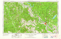
~ Alexandria LA topo map, 1:250000 scale, 1 X 2 Degree, Historical, 1953, updated 1963
Alexandria, Louisiana, USGS topographic map dated 1953.
Includes geographic coordinates (latitude and longitude). This topographic map is suitable for hiking, camping, and exploring, or framing it as a wall map.
Printed on-demand using high resolution imagery, on heavy weight and acid free paper, or alternatively on a variety of synthetic materials.
Topos available on paper, Waterproof, Poly, or Tyvek. Usually shipping rolled, unless combined with other folded maps in one order.
- Product Number: USGS-5595156
- Free digital map download (high-resolution, GeoPDF): Alexandria, Louisiana (file size: 20 MB)
- Map Size: please refer to the dimensions of the GeoPDF map above
- Weight (paper map): ca. 55 grams
- Map Type: POD USGS Topographic Map
- Map Series: HTMC
- Map Verison: Historical
- Cell ID: 68641
- Scan ID: 335205
- Imprint Year: 1963
- Woodland Tint: Yes
- Aerial Photo Year: 1953
- Edit Year: 1962
- Field Check Year: 1953
- Datum: Unstated
- Map Projection: Transverse Mercator
- Map published by United States Army
- Map Language: English
- Scanner Resolution: 600 dpi
- Map Cell Name: Alexandria
- Grid size: 1 X 2 Degree
- Date on map: 1953
- Map Scale: 1:250000
- Geographical region: Louisiana, United States
Neighboring Maps:
All neighboring USGS topo maps are available for sale online at a variety of scales.
Spatial coverage:
Topo map Alexandria, Louisiana, covers the geographical area associated the following places:
- Whitford - Leesville - Rock - Pineland - Five Forks - Caney - Rattan - Tower Estates Number 2 - Saint Maurice - Buckeye - Shady Grove - Slagle - Fort Randolph - Lakeview - Loring - Derry - Fairview Acres - Zwolle - Bagdad - Smith (historical) - Rosevine - Lewiston - Oak Grove - Robeline - Santiago (historical) - Negreet - Joyce - Union Springs - Billy Goat Hill - Montcla - Hagewood - Gorum - Clifton Crossing - Barron - Blackjack - Sandel - Price Crossing - Dolette (historical) - Toledo - Holum - Bob - Hagen (historical) - Kadesh - Mason - Columbus (historical) - Trout - Coldwater - Mitchell - Allen - Old Montgomery (historical) - Couley - Spring Ridge - Packton - Wheeling - Browndell - Fisherville - Grove Hill - Sexton - Belle d'Eau - Simms - Camp Hardtner - Provencal - Hatfield - Winnfield - Givens (historical) - Cheneyville - Iatt - Hicks Crossing - Howcott - Turtle Beach - Wallace - Manistee (historical) - Tower Trailer Park - Haddens - Sharp Town - Dobs Crossing - Halcyon (historical) - Recknor (historical) - Hyams - Wardville - Kingsville - Black Creek (historical) - Fairfield - Paradise - Midway - Wilson Point - New Llano - Stille - Everett (historical) - Pinegrove (historical) - The Rock - Fern - Bethel - Hollingsworth - Lotus - Rochelle - Williana - Mansura - Magnolia - Toro
- Map Area ID: AREA3231-94-92
- Northwest corner Lat/Long code: USGSNW32-94
- Northeast corner Lat/Long code: USGSNE32-92
- Southwest corner Lat/Long code: USGSSW31-94
- Southeast corner Lat/Long code: USGSSE31-92
- Northern map edge Latitude: 32
- Southern map edge Latitude: 31
- Western map edge Longitude: -94
- Eastern map edge Longitude: -92


