
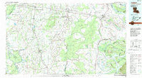
~ Tallulah LA topo map, 1:100000 scale, 30 X 60 Minute, Historical, 1982, updated 1983
Tallulah, Louisiana, USGS topographic map dated 1982.
Includes geographic coordinates (latitude and longitude). This topographic map is suitable for hiking, camping, and exploring, or framing it as a wall map.
Printed on-demand using high resolution imagery, on heavy weight and acid free paper, or alternatively on a variety of synthetic materials.
Topos available on paper, Waterproof, Poly, or Tyvek. Usually shipping rolled, unless combined with other folded maps in one order.
- Product Number: USGS-5595132
- Free digital map download (high-resolution, GeoPDF): Tallulah, Louisiana (file size: 22 MB)
- Map Size: please refer to the dimensions of the GeoPDF map above
- Weight (paper map): ca. 55 grams
- Map Type: POD USGS Topographic Map
- Map Series: HTMC
- Map Verison: Historical
- Cell ID: 68437
- Scan ID: 335192
- Imprint Year: 1983
- Woodland Tint: Yes
- Aerial Photo Year: 1979
- Edit Year: 1982
- Datum: NAD27
- Map Projection: Universal Transverse Mercator
- Map published by United States Geological Survey
- Map Language: English
- Scanner Resolution: 600 dpi
- Map Cell Name: Tallulah
- Grid size: 30 X 60 Minute
- Date on map: 1982
- Map Scale: 1:100000
- Geographical region: Louisiana, United States
Neighboring Maps:
All neighboring USGS topo maps are available for sale online at a variety of scales.
Spatial coverage:
Topo map Tallulah, Louisiana, covers the geographical area associated the following places:
- Islington (historical) - Swampers - Ashville (historical) - Scott Landing - Talbot Landing - Quebec - Millikens Bend (historical) - Jigger - New Quarters - Mason - Hurricane - Sunrise Landing - Dehlco - Somerset - Glade Bayou Landing - Coleman - Mangham - Balmoral - Remolina Landing - Crowville - Dunn - Start - Mound - Warsaw Ferry - Crew Lake - Notnac - Dearborn - Lamar - Harris Landing - Richmond - Pecan Landing - Como - Hopewell Landing - Baskinton - Wildcat - Warsaw Landing - Dickey Landing - Big Creek - Longview - Ferry Newlight Landing - Fredericksburg (historical) - New Carthage (historical) - Englewood - Waverly - Sacksonia - Alto - Thomastown - Quimby - Indian Landing - Stones Landing - Tendal - Jackson Landing - Tensas Bluff Landing - Bushes - Newellton - Tallulah - Peelers - Grand Gulf - Buckner - Rayville - Waller Landing - Afton - Tensas - Fortune Fork - Delhi - County Landing - Girard - Fort Necessity - Buie - Bee Bayou - Gilleyville - Saranac - Charlieville - Hebert - Brownell - Griffin - Oakwood Landing - Allen - Lorelein - Oakley Landing - Chase - Altoona - Talla Bena - New Light - Dixie Landing - King - Ashly - Westwood - Millhaven - Lums - Rhymes - Barnes - Gilbert - Chelly Landing - Bakers - Bedford - Mansford - Baskin - Four Forks - Liddieville
- Map Area ID: AREA32.532-92-91
- Northwest corner Lat/Long code: USGSNW32.5-92
- Northeast corner Lat/Long code: USGSNE32.5-91
- Southwest corner Lat/Long code: USGSSW32-92
- Southeast corner Lat/Long code: USGSSE32-91
- Northern map edge Latitude: 32.5
- Southern map edge Latitude: 32
- Western map edge Longitude: -92
- Eastern map edge Longitude: -91


