
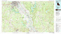
~ Shreveport South LA topo map, 1:100000 scale, 30 X 60 Minute, Historical, 1985, updated 1988
Shreveport South, Louisiana, USGS topographic map dated 1985.
Includes geographic coordinates (latitude and longitude). This topographic map is suitable for hiking, camping, and exploring, or framing it as a wall map.
Printed on-demand using high resolution imagery, on heavy weight and acid free paper, or alternatively on a variety of synthetic materials.
Topos available on paper, Waterproof, Poly, or Tyvek. Usually shipping rolled, unless combined with other folded maps in one order.
- Product Number: USGS-5595130
- Free digital map download (high-resolution, GeoPDF): Shreveport South, Louisiana (file size: 28 MB)
- Map Size: please refer to the dimensions of the GeoPDF map above
- Weight (paper map): ca. 55 grams
- Map Type: POD USGS Topographic Map
- Map Series: HTMC
- Map Verison: Historical
- Cell ID: 68363
- Scan ID: 335191
- Imprint Year: 1988
- Woodland Tint: Yes
- Aerial Photo Year: 1983
- Edit Year: 1985
- Datum: NAD27
- Map Projection: Universal Transverse Mercator
- Map published by United States Geological Survey
- Map Language: English
- Scanner Resolution: 600 dpi
- Map Cell Name: Shreveport South
- Grid size: 30 X 60 Minute
- Date on map: 1985
- Map Scale: 1:100000
- Geographical region: Louisiana, United States
Neighboring Maps:
All neighboring USGS topo maps are available for sale online at a variety of scales.
Spatial coverage:
Topo map Shreveport South, Louisiana, covers the geographical area associated the following places:
- Willow Ridge - Morameal - Western Hills Estates - Mayers - Dona (historical) - Shadow Pine Estates - Linsberry (historical) - Armistead - Waterwood Estates - Wildwood South - Forest Villa - Elmwood (historical) - Woodchuck - Palmer Landing - Holly Hill - Magnolia - Methvin - Live Oak - Greenwood - Chateau Village - Greenwood Hills - Silver Pine Village - Cecile - Palmetto - High Island - Longwood Village - Harwick Place - Ellerbe Woods - Kickapoo - Wildwood - Staples - Southgate Estates - Crichton - Naborton - Liberty - Knot Point - Southern Hills - Bellaire - Pine Grove - Highland Park - Robson - Gloster - Harmon - Westdale - Deep Woods - Cannon - Midway - South Towne Heights - Kolter - Skidder - Holly - Pecan Park - Loggy Bayou - Cynthia Park - Bayou Pierre - Deer Creek Estates - Frierson - Poole - New Hope - Woodstone - Cooterville - Ebenezer - Bayou Pierre - Normandy Village - Sailes - Ashland - Magenta - Plum Orchard Landing - Alberta - Meadow Creek Estates - Southern Gardens - Jamestown - Tullis - Guynes - Burkplace - Hollywood - Elkins - Whitley (historical) - Old Castor - Nichols (historical) - Carmel - Naylor - Pine Forest - Porter Place - Longstreet - Broadview - Lucas - Steeple Chase - Norton - De Soto Heights - Caspiana - Caplis - Westwood Park - Golden Meadows - Edgewood Village - Keithville - Slone - King Forest - Carroll - Greenbrook
- Map Area ID: AREA32.532-94-93
- Northwest corner Lat/Long code: USGSNW32.5-94
- Northeast corner Lat/Long code: USGSNE32.5-93
- Southwest corner Lat/Long code: USGSSW32-94
- Southeast corner Lat/Long code: USGSSE32-93
- Northern map edge Latitude: 32.5
- Southern map edge Latitude: 32
- Western map edge Longitude: -94
- Eastern map edge Longitude: -93


