
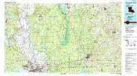
~ Shreveport North LA topo map, 1:100000 scale, 30 X 60 Minute, Historical, 1986, updated 1988
Shreveport North, Louisiana, USGS topographic map dated 1986.
Includes geographic coordinates (latitude and longitude). This topographic map is suitable for hiking, camping, and exploring, or framing it as a wall map.
Printed on-demand using high resolution imagery, on heavy weight and acid free paper, or alternatively on a variety of synthetic materials.
Topos available on paper, Waterproof, Poly, or Tyvek. Usually shipping rolled, unless combined with other folded maps in one order.
- Product Number: USGS-5595126
- Free digital map download (high-resolution, GeoPDF): Shreveport North, Louisiana (file size: 32 MB)
- Map Size: please refer to the dimensions of the GeoPDF map above
- Weight (paper map): ca. 55 grams
- Map Type: POD USGS Topographic Map
- Map Series: HTMC
- Map Verison: Historical
- Cell ID: 68362
- Scan ID: 335189
- Imprint Year: 1988
- Woodland Tint: Yes
- Aerial Photo Year: 1982
- Edit Year: 1986
- Datum: NAD27
- Map Projection: Universal Transverse Mercator
- Map published by United States Geological Survey
- Map Language: English
- Scanner Resolution: 600 dpi
- Map Cell Name: Shreveport North
- Grid size: 30 X 60 Minute
- Date on map: 1986
- Map Scale: 1:100000
- Geographical region: Louisiana, United States
Neighboring Maps:
All neighboring USGS topo maps are available for sale online at a variety of scales.
Spatial coverage:
Topo map Shreveport North, Louisiana, covers the geographical area associated the following places:
- Dubberly - Northwoods - Dune Estates - Oak Thicket Acres - Dorcheat - Bodcau - Wafer Forest - Carterville - Lakeview - Audrey Park - Dogwood Hills - Lakeshore North - Willow Chute - Highland Square - Cloverdale - Fillmore - Shipp - Sibley - Redland - Spring Lake - Parkland Village - Airline Park Estates - Dayson - Mimosa Gardens - North Shreveport - Good Roads - Carriage Oaks - Ivan - Norton Corner - Oaks - Cash Point - Cooper Road - Mooringsport - Blanchard - Alden Bridge - Minden - McKenzie - Brownlee Estates - Frog Level (historical) - Placid (historical) - Overton (historical) - Mount Lebanon - Meadow Creek Ranch - Swindleville - Vanceville - Mira - Fosters - Arlatex - Phillips - Porterville - Hinkle - Brent - Ada - Gibsland - Tall Timbers - Dorian Terrace - Pine Hill Estates - Baccus - Holly Springs - Southern Terrace - Dogwood Forest - North Highlands - Rocky Mount - Princeton - Lakeside Acres - Dogwood Park - Connells (historical) - Myrtis - Conn - Waller - Grim - Darley - North Park Estates - Ruple - Shady Park - Benton - Sentell - Athens - Shoreline - Sarepta - Caddo - South Shore Estates - Swan Lake - Bunker - Hortman - Haynesville - Holly Ridge - Superior - Old Shongaloo - Dykesville - Millwood Estates - Collinsburg - Bellevue - East Side Subdivision - Timothy (historical) - Wardview - Meadow Creek Subdivision - Mahan - Dukedale - Hidden Harbor Estates
- Map Area ID: AREA3332.5-94-93
- Northwest corner Lat/Long code: USGSNW33-94
- Northeast corner Lat/Long code: USGSNE33-93
- Southwest corner Lat/Long code: USGSSW32.5-94
- Southeast corner Lat/Long code: USGSSE32.5-93
- Northern map edge Latitude: 33
- Southern map edge Latitude: 32.5
- Western map edge Longitude: -94
- Eastern map edge Longitude: -93


