
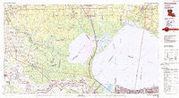
~ Ponchatoula LA topo map, 1:100000 scale, 30 X 60 Minute, Historical, 1983, updated 1984
Ponchatoula, Louisiana, USGS topographic map dated 1983.
Includes geographic coordinates (latitude and longitude). This topographic map is suitable for hiking, camping, and exploring, or framing it as a wall map.
Printed on-demand using high resolution imagery, on heavy weight and acid free paper, or alternatively on a variety of synthetic materials.
Topos available on paper, Waterproof, Poly, or Tyvek. Usually shipping rolled, unless combined with other folded maps in one order.
- Product Number: USGS-5595120
- Free digital map download (high-resolution, GeoPDF): Ponchatoula, Louisiana (file size: 26 MB)
- Map Size: please refer to the dimensions of the GeoPDF map above
- Weight (paper map): ca. 55 grams
- Map Type: POD USGS Topographic Map
- Map Series: HTMC
- Map Verison: Historical
- Cell ID: 68174
- Scan ID: 335186
- Imprint Year: 1984
- Woodland Tint: Yes
- Edit Year: 1983
- Datum: NAD27
- Map Projection: Universal Transverse Mercator
- Map published by United States Geological Survey
- Map Language: English
- Scanner Resolution: 600 dpi
- Map Cell Name: Ponchatoula
- Grid size: 30 X 60 Minute
- Date on map: 1983
- Map Scale: 1:100000
- Geographical region: Louisiana, United States
Neighboring Maps:
All neighboring USGS topo maps are available for sale online at a variety of scales.
Spatial coverage:
Topo map Ponchatoula, Louisiana, covers the geographical area associated the following places:
- Maurepas - Belmont - Deville's Mobile Home Park - Weber City - Hungarian Settlement - Oak Forest Mobile Home Park - Goodbee - Neal Landing - Katie (historical) - Bankstons Mobile Home Park - West Lake - Killona - Brignac - Pounds Mobile Home Park - Wall Settlement - Remy - Oubre - Big D Mobile Home Park - Timberton (historical) - Intersection Connection Mobile Home Park - Comeaux Mobile Park - Seabrook - Aben - Burton (historical) - Dolsen - Rapidan - North Pass - Gentilly - Port Vincent - Ridgecrest Mobile Home Park - Pine Village - Hymel - Bedico - Lees Landing - Lake Terrace - Helvetia - Pumpkin Center - Garyville - Corbin - Donaldsonville - Gentilly Woods - Bucktown - Killian - Bend - Welcome - Claiborne Hill - Southern Mobile Home Park - Poley - Eden Church Road Mobile Park - Brittany - White Hall - Strader - Darrow - Wind Crest Mobile Home Park - Barmen - Dunson Mobile Home Park - Rearwood (historical) - Edgard - West End - Minnie (historical) - Wallace - Rosaryville - Flamingo Recreational Vehicle and Mobile Home Park - Denham Springs - Marathon - Lakewood (historical) - Saint Elmo - Colonial Mobile Home Park - Hope Villa - Humphries (historical) - Wadesboro - Sport - Denson - Abita Springs - Duke (historical) - Grand View (historical) - Riverland Heights - Brulie Maurin - Central - Verdun - Cypress Creek Mobile Home Court - Southwood Ridge - Seven Oaks Mobile Home Park - Little Prairie - Bowden - Carrollwood - Campbell - Gypsy - Colomb Park (historical) - S and H Mobile Home Park - Westgate - Burnside - Carthage Bluff Landing - Bonaire Estates - Horse Bluff Landing - Cofield - Convent - Lauderdale - Romeville - A and W Mobile Home Park
- Map Area ID: AREA30.530-91-90
- Northwest corner Lat/Long code: USGSNW30.5-91
- Northeast corner Lat/Long code: USGSNE30.5-90
- Southwest corner Lat/Long code: USGSSW30-91
- Southeast corner Lat/Long code: USGSSE30-90
- Northern map edge Latitude: 30.5
- Southern map edge Latitude: 30
- Western map edge Longitude: -91
- Eastern map edge Longitude: -90


