
~ New Orleans LA topo map, 1:100000 scale, 30 X 60 Minute, Historical, 1983, updated 1983
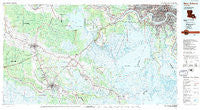
New Orleans, Louisiana, USGS topographic map dated 1983.
Includes geographic coordinates (latitude and longitude). This topographic map is suitable for hiking, camping, and exploring, or framing it as a wall map.
Printed on-demand using high resolution imagery, on heavy weight and acid free paper, or alternatively on a variety of synthetic materials.
Topos available on paper, Waterproof, Poly, or Tyvek. Usually shipping rolled, unless combined with other folded maps in one order.
- Product Number: USGS-5595112
- Free digital map download (high-resolution, GeoPDF): New Orleans, Louisiana (file size: 28 MB)
- Map Size: please refer to the dimensions of the GeoPDF map above
- Weight (paper map): ca. 55 grams
- Map Type: POD USGS Topographic Map
- Map Series: HTMC
- Map Verison: Historical
- Cell ID: 68042
- Scan ID: 335182
- Imprint Year: 1983
- Woodland Tint: Yes
- Visual Version Number: 1
- Aerial Photo Year: 1978
- Edit Year: 1983
- Datum: NAD27
- Map Projection: Universal Transverse Mercator
- Map published by United States Geological Survey
- Map Language: English
- Scanner Resolution: 600 dpi
- Map Cell Name: New Orleans
- Grid size: 30 X 60 Minute
- Date on map: 1983
- Map Scale: 1:100000
- Geographical region: Louisiana, United States
Neighboring Maps:
All neighboring USGS topo maps are available for sale online at a variety of scales.
Spatial coverage:
Topo map New Orleans, Louisiana, covers the geographical area associated the following places:
- McDonoghville - Terrytown - Lafayette (historical) - Cypress Gardens - Gloria - Magnolia Plantation - Circle West Mobile Homes Estates - Beverly Knoll - Bertie - Camardelle - Ollie - Oakville - Lafitte - Myrtle Grove (historical) - Dixie Plantation - Orlandos Mobile Home Park - Elmwood - Carrollton - Paradis - Laurel Valley Plantation - Acadia - Davis (historical) - Magnolia - Circle G Mobile Home Park - Gray - Solars Mobile Home Park - New Orleans - Ama - Saint James - Star - Presquille - Jefferson - Chegby - Hollywood - Houma - Brule - Harahan - Faubourg Marigny - River Ridge - Frellsen - Whispering Oaks Mobile Home and Recreational Vehicle Park - Naquin - Ingleside - Live Oak - Jefferson Heights - Schriever - Carriage Cove Mobile Home Park - Thibodaux - Southdown Plantation - Pricetown (historical) - Faith Trailer Court - Ardoyne - Choctaw - Lazy Acres - Corso - Hahnville - Godchaux - Bayou Cane - Kenner - Rebecca Plantation - Almedia - Bayou Boeuf - McBride - Floyd Court Mobile Home Park - Oak Forest - Rita - Rosedale - Mathews - Plantation Acres - Southport - Metairie - New Sarpy - Capri Court Mobile Home Park - Brandywine - Waterproof - Minerva Plantation - Webre Steib Plantation - Avondale - L T Plantation - Woodland Heights Mobile Home Community - Concession - Sunshine - Greenville - Mulberry - White Plantation - Laurel Ridge Plantation - Southdown - Oak Ridge Park - Morvant - Abby Plantation - Bayou Cane - Orange Grove Plantation - Chacahoula - Bayou Gauche - Crozier - Lowlands - Cedar Grove Plantation - H and D Mobile Home Park - Greenwood - Allemand
- Map Area ID: AREA3029.5-91-90
- Northwest corner Lat/Long code: USGSNW30-91
- Northeast corner Lat/Long code: USGSNE30-90
- Southwest corner Lat/Long code: USGSSW29.5-91
- Southeast corner Lat/Long code: USGSSE29.5-90
- Northern map edge Latitude: 30
- Southern map edge Latitude: 29.5
- Western map edge Longitude: -91
- Eastern map edge Longitude: -90


