
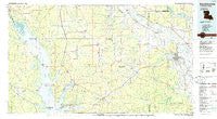
~ Natchitoches LA topo map, 1:100000 scale, 30 X 60 Minute, Historical, 1986, updated 1986
Natchitoches, Louisiana, USGS topographic map dated 1986.
Includes geographic coordinates (latitude and longitude). This topographic map is suitable for hiking, camping, and exploring, or framing it as a wall map.
Printed on-demand using high resolution imagery, on heavy weight and acid free paper, or alternatively on a variety of synthetic materials.
Topos available on paper, Waterproof, Poly, or Tyvek. Usually shipping rolled, unless combined with other folded maps in one order.
- Product Number: USGS-5595106
- Free digital map download (high-resolution, GeoPDF): Natchitoches, Louisiana (file size: 21 MB)
- Map Size: please refer to the dimensions of the GeoPDF map above
- Weight (paper map): ca. 55 grams
- Map Type: POD USGS Topographic Map
- Map Series: HTMC
- Map Verison: Historical
- Cell ID: 68030
- Scan ID: 335179
- Imprint Year: 1986
- Woodland Tint: Yes
- Aerial Photo Year: 1981
- Edit Year: 1986
- Datum: NAD27
- Map Projection: Universal Transverse Mercator
- Planimetric: Yes
- Map published by United States Geological Survey
- Map Language: English
- Scanner Resolution: 600 dpi
- Map Cell Name: Natchitoches
- Grid size: 30 X 60 Minute
- Date on map: 1986
- Map Scale: 1:100000
- Geographical region: Louisiana, United States
Neighboring Maps:
All neighboring USGS topo maps are available for sale online at a variety of scales.
Spatial coverage:
Topo map Natchitoches, Louisiana, covers the geographical area associated the following places:
- Sardis - Timon - Hunter - Knightville (historical) - Fort Jesup - Greenwood Park - Dreka - Lula - Bermuda - Westlake - Forest - Natchez - Noble - Hamlin (historical) - Evelyn - Shamrock - Fairview Alpha - Patroon - Beechwood Estates - Grand Ecore - Grove Hill - Cobbs Addition - Mineral (historical) - Rambin - Clarence - Isla - Dolette (historical) - Bethel - Breedlove Hills - Spider (historical) - Ajax - Oakleaf Estates - Lake End - West Hamilton (historical) - Oak Grove - King Hill - Huxley - Shady Grove - Flora - Hanna - Butler (historical) - Cook (historical) - Harris - Vowells Mill - Mitchell - Victoria - Oak Grove - East Natchitoches - Logansport - Stanley - Goober Hill - Irma - Alliance - Sexton - Zwolle - Coker - Pleasant Hill - Cypress - Fairview Acres - Adois (historical) - Spring Ridge - Wood - Chinquapin Park - Union Springs - Hollingsworth - Robeline - Calvert Acres - Vienna Bend - Catuna - Marthaville - Shamard Heights - Pelican - Converse - New Harmony - Campti - Belmont - Pleasant Hill - Redoak - Los Adaes (historical) - Bayou Scie - Wallace - Red Dirt (historical) - Trenton - Hyams - Provencal - Oxford - Benson - Paragon (historical) - Grappes Bluff - Highland Acres - Jordans Store - Ragtown - Kraft - Alford Heights - Piermont - Allen - Oakhill - Many - Clyde - Natchitoches
- Map Area ID: AREA3231.5-94-93
- Northwest corner Lat/Long code: USGSNW32-94
- Northeast corner Lat/Long code: USGSNE32-93
- Southwest corner Lat/Long code: USGSSW31.5-94
- Southeast corner Lat/Long code: USGSSE31.5-93
- Northern map edge Latitude: 32
- Southern map edge Latitude: 31.5
- Western map edge Longitude: -94
- Eastern map edge Longitude: -93


