
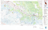
~ Morgan City LA topo map, 1:100000 scale, 30 X 60 Minute, Historical, 1983, updated 1983
Morgan City, Louisiana, USGS topographic map dated 1983.
Includes geographic coordinates (latitude and longitude). This topographic map is suitable for hiking, camping, and exploring, or framing it as a wall map.
Printed on-demand using high resolution imagery, on heavy weight and acid free paper, or alternatively on a variety of synthetic materials.
Topos available on paper, Waterproof, Poly, or Tyvek. Usually shipping rolled, unless combined with other folded maps in one order.
- Product Number: USGS-5595104
- Free digital map download (high-resolution, GeoPDF): Morgan City, Louisiana (file size: 30 MB)
- Map Size: please refer to the dimensions of the GeoPDF map above
- Weight (paper map): ca. 55 grams
- Map Type: POD USGS Topographic Map
- Map Series: HTMC
- Map Verison: Historical
- Cell ID: 67988
- Scan ID: 335178
- Imprint Year: 1983
- Woodland Tint: Yes
- Aerial Photo Year: 1975
- Edit Year: 1983
- Datum: NAD27
- Map Projection: Universal Transverse Mercator
- Map published by United States Geological Survey
- Map Language: English
- Scanner Resolution: 600 dpi
- Map Cell Name: Morgan City
- Grid size: 30 X 60 Minute
- Date on map: 1983
- Map Scale: 1:100000
- Geographical region: Louisiana, United States
Neighboring Maps:
All neighboring USGS topo maps are available for sale online at a variety of scales.
Spatial coverage:
Topo map Morgan City, Louisiana, covers the geographical area associated the following places:
- Maryland - Garden City - Wildwood - Ivanhoe - Balco - Sandager - Morgan City - Bayou Vista - Kilgore Plantation - Prevost - Numa - Bob Acres - Bodin - Fivemile Oaks - Ashton - Davids - Dennison - Belle River - Calumet - Burns - Elm Hall Junction - Ramos - Ellerslie - Bayou Sale - Oakley - M and T Mobile Home Park - Pesson - Alice B - Oxford - Idlewild - Zacarter - Gajan - Matilda - Glenwild - Derouen - Port of Iberia - Loisel - Munsons - Paincourtville - Little Texas - United - Freetown - Plattenville - Gold Mine - Katy - Lower Texas - Stephenville - Patoutville - Rodriquez - Brannon - Parro Mobile Home Park - Gall - Todd - Saint Thomas - Dumesnil - North Bend - Delaware - Luke Landing - Englewood - Charenton - Avalon - Little Valley Plantation - Florence - Verdunville - Maria - Lifenite - Greig - Baldwin - Brousville - Tree Lawn Trailer Court - Johnson - Richard - Attakapas Canal - Pines Lane Mobile Home Park - Cypremort - Four Corners - Cabot - Church Spur - Morgan City Beach - Enola - Emma - Jefferson Island - Ricohoc - Landry - Brusle Saint Vincent - Norbert - Lagonda - Centerville - Netpinunsh (historical) - Duboin - Kemper - Avoca - Lydia - Elm Hall - Violas Mobile Home Park - Fairville - Leleux - Clausen - Home Place - Weeks
- Map Area ID: AREA3029.5-92-91
- Northwest corner Lat/Long code: USGSNW30-92
- Northeast corner Lat/Long code: USGSNE30-91
- Southwest corner Lat/Long code: USGSSW29.5-92
- Southeast corner Lat/Long code: USGSSE29.5-91
- Northern map edge Latitude: 30
- Southern map edge Latitude: 29.5
- Western map edge Longitude: -92
- Eastern map edge Longitude: -91


