
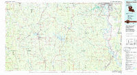
~ Monroe South LA topo map, 1:100000 scale, 30 X 60 Minute, Historical, 1985, updated 1985
Monroe South, Louisiana, USGS topographic map dated 1985.
Includes geographic coordinates (latitude and longitude). This topographic map is suitable for hiking, camping, and exploring, or framing it as a wall map.
Printed on-demand using high resolution imagery, on heavy weight and acid free paper, or alternatively on a variety of synthetic materials.
Topos available on paper, Waterproof, Poly, or Tyvek. Usually shipping rolled, unless combined with other folded maps in one order.
- Product Number: USGS-5595100
- Free digital map download (high-resolution, GeoPDF): Monroe South, Louisiana (file size: 20 MB)
- Map Size: please refer to the dimensions of the GeoPDF map above
- Weight (paper map): ca. 55 grams
- Map Type: POD USGS Topographic Map
- Map Series: HTMC
- Map Verison: Historical
- Cell ID: 67975
- Scan ID: 335176
- Imprint Year: 1985
- Woodland Tint: Yes
- Aerial Photo Year: 1983
- Edit Year: 1985
- Datum: NAD27
- Map Projection: Universal Transverse Mercator
- Planimetric: Yes
- Map published by United States Geological Survey
- Map Language: English
- Scanner Resolution: 600 dpi
- Map Cell Name: Monroe South
- Grid size: 30 X 60 Minute
- Date on map: 1985
- Map Scale: 1:100000
- Geographical region: Louisiana, United States
Neighboring Maps:
All neighboring USGS topo maps are available for sale online at a variety of scales.
Spatial coverage:
Topo map Monroe South, Louisiana, covers the geographical area associated the following places:
- Green Terrace - Jonesboro - Vixen - Siloam Springs - Hebron - Brewtons Mill - New Friendship - Blume - Mount Hebron - Robinson Place - Maidco - Bryceland - Richwood - Womack - Huntington Park - Carolina - Siegle - Dodson - Bellevue - Charmingdale - Cobb - North Hodge - Bear Creek - Kelleys - Mount Pleasant - Sunnybrook Farms - Cotton Plant - Mount Zion (historical) - Oak Grove - Boatner (historical) - Clarks - Mulberry Hill (historical) - Cadeville - Wood Junction - Myatt (historical) - Hudson - McLain - Punkin Center - Woodville - Crowson - Gaars Mill - Blankston - Readheimer - Eros - Old Newport (historical) - Dalley (historical) - Walker - Clay - Saint Claire - Vernon - Bienville - Antioch - Ebenzer - Westwood - Cuba - Fondale - Cox Crossing - Gansville - Erco - Longstraw - Saint Rest - Pleasant Hill - Driscoll (historical) - East Hodge - Old Mount Pleasant (historical) - Filhiol - Bosco - Friendship - Lapine - East Parkview - Cooper (historical) - Anabel - Grayson - Gulf Crossing - Liberty Hill - Lincoln Park - Columbia - Shull (historical) - Chester - Rilla - Crockett (historical) - Mount Pleasant - Summit - Lyons - Mineral Springs - Riverton - Zion Hill (historical) - Pino Bayou Village - Kings Oaks - Pratt - Wyatt - Lenwil - Cypress - Milams - Goldonna - Pine Grove - Concord - Loe - Bawcomville - Garden Park
- Map Area ID: AREA32.532-93-92
- Northwest corner Lat/Long code: USGSNW32.5-93
- Northeast corner Lat/Long code: USGSNE32.5-92
- Southwest corner Lat/Long code: USGSSW32-93
- Southeast corner Lat/Long code: USGSSE32-92
- Northern map edge Latitude: 32.5
- Southern map edge Latitude: 32
- Western map edge Longitude: -93
- Eastern map edge Longitude: -92


