
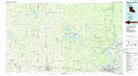
~ Monroe North LA topo map, 1:100000 scale, 30 X 60 Minute, Historical, 1985, updated 1986
Monroe North, Louisiana, USGS topographic map dated 1985.
Includes geographic coordinates (latitude and longitude). This topographic map is suitable for hiking, camping, and exploring, or framing it as a wall map.
Printed on-demand using high resolution imagery, on heavy weight and acid free paper, or alternatively on a variety of synthetic materials.
Topos available on paper, Waterproof, Poly, or Tyvek. Usually shipping rolled, unless combined with other folded maps in one order.
- Product Number: USGS-5595094
- Free digital map download (high-resolution, GeoPDF): Monroe North, Louisiana (file size: 22 MB)
- Map Size: please refer to the dimensions of the GeoPDF map above
- Weight (paper map): ca. 55 grams
- Map Type: POD USGS Topographic Map
- Map Series: HTMC
- Map Verison: Historical
- Cell ID: 67974
- Scan ID: 335173
- Imprint Year: 1986
- Woodland Tint: Yes
- Aerial Photo Year: 1983
- Edit Year: 1985
- Datum: NAD27
- Map Projection: Universal Transverse Mercator
- Planimetric: Yes
- Map published by United States Geological Survey
- Map Language: English
- Scanner Resolution: 600 dpi
- Map Cell Name: Monroe North
- Grid size: 30 X 60 Minute
- Date on map: 1985
- Map Scale: 1:100000
- Geographical region: Louisiana, United States
Neighboring Maps:
All neighboring USGS topo maps are available for sale online at a variety of scales.
Spatial coverage:
Topo map Monroe North, Louisiana, covers the geographical area associated the following places:
- Alabama Landing - Sterlington - Shiloh Landing (historical) - Colsons (historical) - De Loutre - Farmerville - Northpark Village - Sadie - Bridges Mill - Weldon - West Sterlington - Sugar Creek - Trace Estates - D'Arbonne Hills - Terrills - West Monroe - Dean - Mount Olive - Wall Lake - Chauvin Estates - Bernice - Grambling Corners - Pecan Bayou - Old Ten - Marion - Gills Ferry - Frizzell Spur - Indian Lake Estates - Aycock - Cox Ferry - Randolph - Choudrant - Upco - Forest Home - Hebron - Monroe - La Mesa - Valley Hills - Shenandoah - Henry - Cargas - Sumpter (historical) - De Siard - Cooktown - Litroe - Unionville - Monroe - Carroll (historical) - Royal Pines - Sherwood Forest - Hammock - Hillside Park - Moselys Bluff - Treasure Island - Lisbon - Evergreen - Scottsville - Dubach - Casa Linda - Arizona - Forest Park - Carlton - Fairbanks - D'Arbonne - Barnet Springs - Fords - Calhoun - Rockthrow - Perryville - Colquitt - Pine Hollow Estates - Sylvan Lake Estates - Burgessville (historical) - Summerfield - Tupawek - Claiborne - Eureka - Pleasant Valley - Sunshine Heights - Truxno - Northgate - Wise (historical) - Rock Corner - Crosley - Belle Meade - Crossroads - Laran - Tulip - River Oaks - Fish Creek - Wards Mill (historical) - Green Springs - Grambling - Kiroli Woods - Haile - Walnut Lane (historical) - Rum Center - Antioch - Shiloh - Tremont
- Map Area ID: AREA3332.5-93-92
- Northwest corner Lat/Long code: USGSNW33-93
- Northeast corner Lat/Long code: USGSNE33-92
- Southwest corner Lat/Long code: USGSSW32.5-93
- Southeast corner Lat/Long code: USGSSE32.5-92
- Northern map edge Latitude: 33
- Southern map edge Latitude: 32.5
- Western map edge Longitude: -93
- Eastern map edge Longitude: -92


