
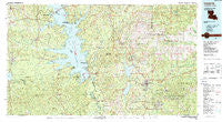
~ Leesville LA topo map, 1:100000 scale, 30 X 60 Minute, Historical, 1986, updated 1988
Leesville, Louisiana, USGS topographic map dated 1986.
Includes geographic coordinates (latitude and longitude). This topographic map is suitable for hiking, camping, and exploring, or framing it as a wall map.
Printed on-demand using high resolution imagery, on heavy weight and acid free paper, or alternatively on a variety of synthetic materials.
Topos available on paper, Waterproof, Poly, or Tyvek. Usually shipping rolled, unless combined with other folded maps in one order.
- Product Number: USGS-5595092
- Free digital map download (high-resolution, GeoPDF): Leesville, Louisiana (file size: 32 MB)
- Map Size: please refer to the dimensions of the GeoPDF map above
- Weight (paper map): ca. 55 grams
- Map Type: POD USGS Topographic Map
- Map Series: HTMC
- Map Verison: Historical
- Cell ID: 67833
- Scan ID: 335170
- Imprint Year: 1988
- Woodland Tint: Yes
- Aerial Photo Year: 1981
- Edit Year: 1986
- Datum: NAD27
- Map Projection: Universal Transverse Mercator
- Map published by United States Geological Survey
- Map Language: English
- Scanner Resolution: 600 dpi
- Map Cell Name: Leesville
- Grid size: 30 X 60 Minute
- Date on map: 1986
- Map Scale: 1:100000
- Geographical region: Louisiana, United States
Neighboring Maps:
All neighboring USGS topo maps are available for sale online at a variety of scales.
Spatial coverage:
Topo map Leesville, Louisiana, covers the geographical area associated the following places:
- Lee Hills - Kurthwood - Dess - Peason - Recknor (historical) - Harrisburg - Mink - Fertitta Park - Magasco - Collins - Sabinetown - Rosevine - Corleyville - Chateau Place - Mayo - Pineland - Tower Trailer Park - Everett (historical) - Esto - McFarland Heights - Carmenia (historical) - Weeks Settlement - Coburn - Fort Polk - Lyles Addition - Clarktown - Morris Addition - Sandel - Milam - Scrapping Valley - Barham - Indian Hills - Horton - New Llano - West Side - Toro - Caney - Fisherville - Anacoco - McElroy - Kisatchie - Negreet - Allendale - South End - Hemphill - Geneva - Lotus - Hornbeck - Burr Ferry - North Fort Polk - Fairdale - Fisher - Tower Estates Number 1 - Monks Hammock - Walnut Hill - Clare - Mason - Fairmount - Toledo - Hicks - Whispering Pines Estates - Turtle Beach - Mayflower - Pinecrest - South Toledo Bend - Kimberly Heights - Alco - East Side - Dixie - Dusenbury - Stumptown - Elmwood - Brookeland - Lincoln Heights - Browndell - Simpson - Westwood Village - Leesville - Woodlands - Standard - Columbus (historical) - Hickory Ridge - Slagle - Haddens - Billy Goat Hill - Sandy Hill - Savage Fork - Rattan - Kile - Hawthorne - Hutton - Yellowpine - Stringtown - Tower Estates Number 2 - Powell Park - Blackjack - Rock (historical) - West End - Mount Carmel - Coopers
- Map Area ID: AREA31.531-94-93
- Northwest corner Lat/Long code: USGSNW31.5-94
- Northeast corner Lat/Long code: USGSNE31.5-93
- Southwest corner Lat/Long code: USGSSW31-94
- Southeast corner Lat/Long code: USGSSE31-93
- Northern map edge Latitude: 31.5
- Southern map edge Latitude: 31
- Western map edge Longitude: -94
- Eastern map edge Longitude: -93


