
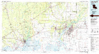
~ Lake Charles LA topo map, 1:100000 scale, 30 X 60 Minute, Historical, 1986, updated 1986
Lake Charles, Louisiana, USGS topographic map dated 1986.
Includes geographic coordinates (latitude and longitude). This topographic map is suitable for hiking, camping, and exploring, or framing it as a wall map.
Printed on-demand using high resolution imagery, on heavy weight and acid free paper, or alternatively on a variety of synthetic materials.
Topos available on paper, Waterproof, Poly, or Tyvek. Usually shipping rolled, unless combined with other folded maps in one order.
- Product Number: USGS-5595090
- Free digital map download (high-resolution, GeoPDF): Lake Charles, Louisiana (file size: 21 MB)
- Map Size: please refer to the dimensions of the GeoPDF map above
- Weight (paper map): ca. 55 grams
- Map Type: POD USGS Topographic Map
- Map Series: HTMC
- Map Verison: Historical
- Cell ID: 67793
- Scan ID: 335169
- Imprint Year: 1986
- Woodland Tint: Yes
- Aerial Photo Year: 1983
- Edit Year: 1986
- Datum: NAD27
- Map Projection: Universal Transverse Mercator
- Map published by United States Geological Survey
- Map Language: English
- Scanner Resolution: 600 dpi
- Map Cell Name: Lake Charles
- Grid size: 30 X 60 Minute
- Date on map: 1986
- Map Scale: 1:100000
- Geographical region: Louisiana, United States
Neighboring Maps:
All neighboring USGS topo maps are available for sale online at a variety of scales.
Spatial coverage:
Topo map Lake Charles, Louisiana, covers the geographical area associated the following places:
- Coughlin - Goss - Goosport - Reese - Robertson - Ruliff - Interstate 10 Mobile Village - Westwood - Lunita - Hartburg - Buhler - Newton - Tulane - Lake Charles - Le Bleu Mobile Home Park - Iowa - Carlyss - Quail Ridge Mobile Home Park - Turps - Prairieland - Hollywood - Rose Bluff - James Mobile Home Park - Deweyville - Gillis - Blankenship Mobile Home Park - Pine Acres Trailer Park - Lucas - Maple Crest Acres - Gordon - Helme - Brownwood - Stark - Lemonville - Vincent Landing - Edgerly - Pine Acres - Gratis - Oakcreek Estates Mobile Home Park - Hacketts Corner - Tommasi Mobile Village - Grand Lake - Ged - Ridgecrest - Bunker Hill - Bessie Heights - Texla - Western Pines - Chardele Mobile Estates - Hecker - Mossville - Bon Air - Choupique - West Orange - Doty - Peveto - Oak Hurst Mobile Home Park - Niblett Bluff - Bayou Shades Mobile Village - Lakewood - Gaytine - Bayou Country Villa Mobile Home Park - Echo - Brimstone - Vinton - Prien - Twin Oaks Mobile Home Park - Bancroft - Bellevue - Gist - Topsy - Gulf Stream Manor Mobile Home Park - Jesse James Mobile Home Park - Gekop - Fairview Recreational Mobile Estates - Chennault Mobile Village - Connell - Greinwich Village - Glen Meadows Mobile Home Park - Oilla - Burton Landing - Bessmay - Sweetgum Community Mobile Home Park - Holmwood - Le Bleu - New Addition - West Bluff - Ben's Mobile Home Park - Maplewood - Evart (historical) - Little Cypress - Mount Dale B Mobile Home Park - Bridge City - Forest Heights - Pinehurst - Sulphur - Morgan Bluff - Southtowner Mobile Estates - Bland - Francis
- Map Area ID: AREA30.530-94-93
- Northwest corner Lat/Long code: USGSNW30.5-94
- Northeast corner Lat/Long code: USGSNE30.5-93
- Southwest corner Lat/Long code: USGSSW30-94
- Southeast corner Lat/Long code: USGSSE30-93
- Northern map edge Latitude: 30.5
- Southern map edge Latitude: 30
- Western map edge Longitude: -94
- Eastern map edge Longitude: -93


