
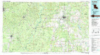
~ DeRidder LA topo map, 1:100000 scale, 30 X 60 Minute, Historical, 1986, updated 1988
DeRidder, Louisiana, USGS topographic map dated 1986.
Includes geographic coordinates (latitude and longitude). This topographic map is suitable for hiking, camping, and exploring, or framing it as a wall map.
Printed on-demand using high resolution imagery, on heavy weight and acid free paper, or alternatively on a variety of synthetic materials.
Topos available on paper, Waterproof, Poly, or Tyvek. Usually shipping rolled, unless combined with other folded maps in one order.
- Product Number: USGS-5595086
- Free digital map download (high-resolution, GeoPDF): DeRidder, Louisiana (file size: 26 MB)
- Map Size: please refer to the dimensions of the GeoPDF map above
- Weight (paper map): ca. 55 grams
- Map Type: POD USGS Topographic Map
- Map Series: HTMC
- Map Verison: Historical
- Cell ID: 67392
- Scan ID: 335167
- Imprint Year: 1988
- Woodland Tint: Yes
- Aerial Photo Year: 1984
- Edit Year: 1986
- Datum: NAD27
- Map Projection: Universal Transverse Mercator
- Map published by United States Geological Survey
- Map Language: English
- Scanner Resolution: 600 dpi
- Map Cell Name: DeRidder
- Grid size: 30 X 60 Minute
- Date on map: 1986
- Map Scale: 1:100000
- Geographical region: Louisiana, United States
Neighboring Maps:
All neighboring USGS topo maps are available for sale online at a variety of scales.
Spatial coverage:
Topo map DeRidder, Louisiana, covers the geographical area associated the following places:
- Trout Creek - Tennant (historical) - Ikes - Insco (historical) - Bon Ami - Adsul - Friendship - Bleakwood - Longacre - Neame - Fulton - Chasmore (historical) - Reeves - A and B Mobile Home Park - Sandjack - Bannister (historical) - Fayette (historical) - Evans - Liberty - Holiday Mobile Home Park - Newlin - Blox - Carson - Hudson Addition - DeRidder - Call - Belgrade - Kirbyville - Dry Creek - Mystic - Edith - Buckhorn - Newton - Burkeville - Oretta - Kipling - Bivens - Tulla - Quicksand - Rosepine - Harrells - Shankleville - Le Verte - Markee - Fields - Wiergate - Jasper - Hite - Kernan - Junction - Ludington - Farrsville - Erin - Longville - Holly Springs - J and E Junction - Neale - Jamestown - Stringtown - Howards - Salem - Knight - New Blox - Sugrue - Evergreen Mobile Home Park - Roganville - Sweetville (historical) - Ragley - Sutton Junction (historical) - Forbes - Call Junction - Pujo - Bon Wier - Pinewood - Bel - Hickory Creek Mobile Home Park - Hoy (historical) - Sugartown - Cravens - Almadane - Fawil - Baggett (historical) - Huff Creek - Broussard Mobile Home Park - Bancroft - Call - Bon Ami - Singer - Pine Grove - Bundick (historical) - Eclipse - Merryville - Seale - Simmonsville - Juanita - Mattox - Keithton - Zion Hill - Shear - Grabow
- Map Area ID: AREA3130.5-94-93
- Northwest corner Lat/Long code: USGSNW31-94
- Northeast corner Lat/Long code: USGSNE31-93
- Southwest corner Lat/Long code: USGSSW30.5-94
- Southeast corner Lat/Long code: USGSSE30.5-93
- Northern map edge Latitude: 31
- Southern map edge Latitude: 30.5
- Western map edge Longitude: -94
- Eastern map edge Longitude: -93


