
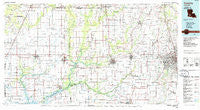
~ Crowley LA topo map, 1:100000 scale, 30 X 60 Minute, Historical, 1985, updated 1986
Crowley, Louisiana, USGS topographic map dated 1985.
Includes geographic coordinates (latitude and longitude). This topographic map is suitable for hiking, camping, and exploring, or framing it as a wall map.
Printed on-demand using high resolution imagery, on heavy weight and acid free paper, or alternatively on a variety of synthetic materials.
Topos available on paper, Waterproof, Poly, or Tyvek. Usually shipping rolled, unless combined with other folded maps in one order.
- Product Number: USGS-5595080
- Free digital map download (high-resolution, GeoPDF): Crowley, Louisiana (file size: 21 MB)
- Map Size: please refer to the dimensions of the GeoPDF map above
- Weight (paper map): ca. 55 grams
- Map Type: POD USGS Topographic Map
- Map Series: HTMC
- Map Verison: Historical
- Cell ID: 67367
- Scan ID: 335164
- Imprint Year: 1986
- Woodland Tint: Yes
- Aerial Photo Year: 1984
- Edit Year: 1985
- Datum: NAD27
- Map Projection: Universal Transverse Mercator
- Map published by United States Geological Survey
- Map Language: English
- Scanner Resolution: 600 dpi
- Map Cell Name: Crowley
- Grid size: 30 X 60 Minute
- Date on map: 1985
- Map Scale: 1:100000
- Geographical region: Louisiana, United States
Neighboring Maps:
All neighboring USGS topo maps are available for sale online at a variety of scales.
Spatial coverage:
Topo map Crowley, Louisiana, covers the geographical area associated the following places:
- Rossignol - Pine Island - Oak Park Estates Mobile Home Park - Thornwell - Gueydan - Brambles Mobile Home Park - Naka - Kings Court Mobile Home Park - Carroll Ann Mobile Home Park - Verret - Elton - La Roulette Mobile Home Park - Shady Acres Mobile Home Park - Flanders - Sunrise Mobile Home Park - Lodi (historical) - Maxie - Paradise Mobile Home Park - Pitreville - Silverwood - Redich - Peach Bloom - Benoit Mobile Park - Williams - Wright - Whittington Heights Mobile Home Park - Cozy Acres Mobile Home Park - Gravel Point - Bendel Gardens - Unatex - Thibodeaux Mobile Home Park - Belle Ridge Mobile Home Park - Whitehouse - Vatican - Credeur Mobile Home Park - Arceneaux - Coverdale - Southern Consumer Mobile Home Park - Woodlawn - Lakeview Mobile Home Park - Prudhomme - Lyons Point - Davids Trailer and Recreational Vehicle Park - Tortue - Laurents Point - Cankton - Going West Mobile Estates - Smiling C Mobile Home Park - Victoria Village Mobile Home Park - Angelles Mobile Home Community - Shorts Mobile Estates - Arbolada Addition - Leroy - Mobile Home Acres - Holiday Mobile Home Villa Park - Carencro - Mire - Melanie Mobile Home Park - Quiet Living Mobile Home Park - Petetin - Niblett - Roberts Cove - Plauches Little Acres Mobile Home Park - Charmon Mobile Home Park - Nezpique - Bell City - Tecos Mobile Home Park - Judd - Cartville (historical) - Shiloh Mobile Home Park - Andrew - Chester Domingue Mobile Home Park - Shuteston - Fenton - Jennings - Roanoke - Mowata - Hathaway - Acadian Acres Mobile Home Park - Kinder - Clifton Mobile Home Park - Edna - Sunset - Cossinade - Basile - C and D Mobile Home Park - Branch - Smittys Mobile Home Park - Ossun - Royal Mobile Home Park - Parkland Mobile Home Park - Lauderdale - Stanley - G and R Mobile Park - Hundley - Tyrone - Country Air Mobile Home Park - Mr B's Mobile Home Park - Mouton - Welsh
- Map Area ID: AREA30.530-93-92
- Northwest corner Lat/Long code: USGSNW30.5-93
- Northeast corner Lat/Long code: USGSNE30.5-92
- Southwest corner Lat/Long code: USGSSW30-93
- Southeast corner Lat/Long code: USGSSE30-92
- Northern map edge Latitude: 30.5
- Southern map edge Latitude: 30
- Western map edge Longitude: -93
- Eastern map edge Longitude: -92


